IMAGES TAKEN NEAR TO
Rhydymain, DOLGELLAU, LL40 2AY
Introduction
This page details the photographs taken nearby to LL40 2AY by members of the Geograph project.
The Geograph project started in 2005 with the aim of publishing, organising and preserving representative images for every square kilometre of Great Britain, Ireland and the Isle of Man.

There are currently over 7.5m images from over14,400 individuals and you can help contribute to the project by visiting https://www.geograph.org.uk
Image Map
Images are licensed for reuse under creativecommons.org/licenses/by-sa/2.0
Notes
- Clicking on the map will re-center to the selected point.
- The higher the marker number, the further away the image location is from the centre of the postcode.
Image Listing (13 Images Found)
Images are licensed for reuse under creativecommons.org/licenses/by-sa/2.0
Image
Details
Distance
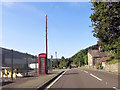
1
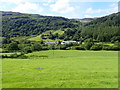
Hamlet at Pont Fronwydd
A small estate of houses and a factory on the A393 between Llanuwchllyn and Rhydymain
Image: © Eirian Evans
Taken: 13 Aug 2019
0.02 miles
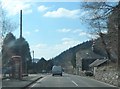
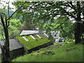
2
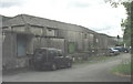
Hen hufenfa Fronwydd. The old creamery at Fronwydd
The creamery was opened in 1954 but was closed in the 1970s as the pattern of local agriculture changed. The buildings are now occupied by a number of companies, including a firm which restores classic cars.
Image: © Eric Jones
Taken: 24 Jul 2007
0.02 miles
3
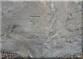
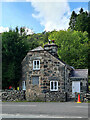
Ordnance Survey Cut Mark
This OS cut mark can be found on the front of the old Toll House (Cott y Bwthyn). It marks a point 177.433
Image: © Adrian Dust
Taken: 9 May 2016
0.02 miles
4
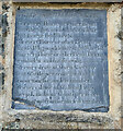
Y Bwthyn, near Dolgellau
Toll Plate on Y Bwthyn (the Cottager), a former Toll House on the A494 between Dolgellau and Bala near Afon Mynach. Built about 1796/8 it served the Bala District Turnpike Trust in the 18/19th C. The Toll house is Image
Listed Building CADW Nᴼ 16046 https://cadwpublic-api.azurewebsites.net/reports/listedbuilding/FullReport?lang=&id=16046
Milestone Society National ID: GWY.RYM2
Image: © Jacqui Parsons
Taken: 14 Aug 2023
0.03 miles
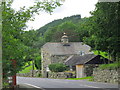
5
Y Bwthyn, near Dolgellau
Y Bwthyn (the Cottager), former Toll House on the A494 between Dolgellau and Bala near Afon Mynach. Built about 1796/8 it served the Bala District Turnpike Trust in the 18/19th C. The Toll Plate is Image
Listed Building CADW Nᴼ 16046 https://cadwpublic-api.azurewebsites.net/reports/listedbuilding/FullReport?lang=&id=16046
Milestone Society National ID: GWY.RYM
Image: © Jacqui Parsons
Taken: 14 Aug 2023
0.03 miles
8
The Old Toll Gate House at Pont Fronwydd
Image: © Eric Jones
Taken: 24 Jul 2007
0.04 miles
10
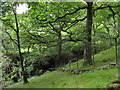
Afon Mynach from the Glan y Mynach path
Mynach means "monk" and Glan y Mynach is "bank of the (river) Monk". In the Middle Ages this area formed part of the sheep pastures of Abaty Cymer Abbey Image
Image: © Eric Jones
Taken: 24 Jul 2007
0.14 miles