IMAGES TAKEN NEAR TO
DOLGELLAU, LL40 1UB
Introduction
This page details the photographs taken nearby to LL40 1UB by members of the Geograph project.
The Geograph project started in 2005 with the aim of publishing, organising and preserving representative images for every square kilometre of Great Britain, Ireland and the Isle of Man.

There are currently over 7.5m images from over14,400 individuals and you can help contribute to the project by visiting https://www.geograph.org.uk
Image Map
Images are licensed for reuse under creativecommons.org/licenses/by-sa/2.0
Notes
- Clicking on the map will re-center to the selected point.
- The higher the marker number, the further away the image location is from the centre of the postcode.
Image Listing (66 Images Found)
Images are licensed for reuse under creativecommons.org/licenses/by-sa/2.0
Image
Details
Distance
1
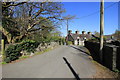
Bridge at Pandy'r-Odyn
Bridge over a small tributary to the Afon Wnion. It's possible that this narrow bit of road was part of the main road into Dolgellau.
Image: © Jeff Buck
Taken: 22 Apr 2015
0.04 miles
2
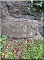
Ordnance Survey Cut Mark
This OS cut mark can be found on the north parapet of Pont Pandyr Odyn. It marks a point 9.209m above mean sea level.
Image: © Adrian Dust
Taken: 9 May 2016
0.04 miles
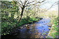
3
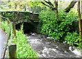
River near Trem-y-Coed
Small tributary of the river Mawddach in Dolgellau.
Image: © Eirian Evans
Taken: 10 May 2012
0.05 miles
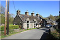
4
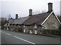
Pretty Terrace.
The road has been raised so much over the years that it's almost half the height of the front doors!
Image: © Hefin Richards
Taken: 16 Jan 2007
0.05 miles
5
Trem y Coed, Dolgellau
Approaching Dolgellau from the west, there is a small lay-by with several stone cottages.
Image: © Eirian Evans
Taken: 10 May 2012
0.05 miles
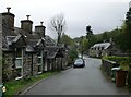
6
Pandy'r-Odyn, Dolgellau
The outskirts of Dolgellau to the west.
Image: © Jeff Buck
Taken: 22 Apr 2015
0.05 miles
7
Tributary to the Afon Wnion
A small unnamed river flowing into the Afon Wnion near Dolgellau.
Image: © Jeff Buck
Taken: 22 Apr 2015
0.06 miles
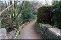
8
Footpath to Dolgellau
Riverside path heading towards Dolgellau.
Image: © Jeff Buck
Taken: 22 Apr 2015
0.07 miles
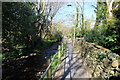
9
Footpath leading to the footbridge over Afon Wnion
And thence to the Mawddach Trail/Cross Britain Way.
Image: © John Lucas
Taken: 31 Mar 2022
0.07 miles
10
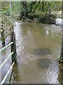
Flooding across the public footpath near Dolgellau
Image: © Lois Rodgers
Taken: 26 Oct 2008
0.08 miles