IMAGES TAKEN NEAR TO
Islawrdref, DOLGELLAU, LL40 1TR
Introduction
This page details the photographs taken nearby to LL40 1TR by members of the Geograph project.
The Geograph project started in 2005 with the aim of publishing, organising and preserving representative images for every square kilometre of Great Britain, Ireland and the Isle of Man.

There are currently over 7.5m images from over14,400 individuals and you can help contribute to the project by visiting https://www.geograph.org.uk
Image Map
Images are licensed for reuse under creativecommons.org/licenses/by-sa/2.0
Notes
- Clicking on the map will re-center to the selected point.
- The higher the marker number, the further away the image location is from the centre of the postcode.
Image Listing (23 Images Found)
Images are licensed for reuse under creativecommons.org/licenses/by-sa/2.0
Image
Details
Distance
1
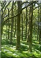
Coed derw yn Islaw'r Dref / Oak trees at Islaw'r Dref
Image: © Ceri Thomas
Taken: 5 Jul 2014
0.09 miles
2
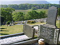
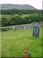
Gravestones in Rehoboth Cemetery
With Welsh language inscriptions, as were most stones in this cemetery.
Image: © William Metcalfe
Taken: 5 May 2007
0.14 miles
3
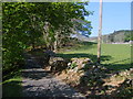
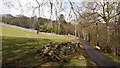
Minor road from Rehoboth Cemetery
This must be the final drive for those resting at Rehoboth Cemetery.
Image: © William Metcalfe
Taken: 5 May 2007
0.15 miles
4
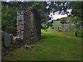
Cemetery
Along the Afon Gwynant Valley is to be found a disused chapel and a cemetery.
Image: © Keith Havercroft
Taken: 22 Jan 2005
0.15 miles
5
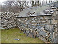
Stone and slate
This building is within the ruined chapel and cemetery site close to the Afon Gwynant Valley.
Image: © Keith Havercroft
Taken: 22 Jan 2005
0.15 miles
6
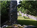
Ruined chapel in cemetery
All that remains of the chapel at Rehoboth Cemetery.
Image: © William Metcalfe
Taken: 26 Aug 2006
0.15 miles
7
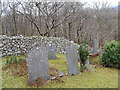
Rehoboth Cemetery
The view from a more recent grave, not yet with a permanent headstone.
Image: © William Metcalfe
Taken: 17 Aug 2007
0.15 miles
8
Rehoboth Cemetery
The cemetery is still used although the chapel is in ruins.
Image: © William Metcalfe
Taken: 17 Aug 2007
0.15 miles
9
Minor road descending towards Kings Youth Hostel
The road descends into the valley of the Gwynant which flows past Kings Youth Hostel.
Image: © Trevor Littlewood
Taken: 19 Apr 2012
0.16 miles
10
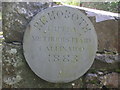
Rehoboth Chapel sign
Sign on the now ruined chapel in the cemetery, which is still used.
Image: © William Metcalfe
Taken: 26 Aug 2006
0.17 miles