IMAGES TAKEN NEAR TO
Bodlondeb Road, DOLGELLAU, LL40 1PT
Introduction
This page details the photographs taken nearby to Bodlondeb Road, LL40 1PT by members of the Geograph project.
The Geograph project started in 2005 with the aim of publishing, organising and preserving representative images for every square kilometre of Great Britain, Ireland and the Isle of Man.

There are currently over 7.5m images from over14,400 individuals and you can help contribute to the project by visiting https://www.geograph.org.uk
Image Map
Images are licensed for reuse under creativecommons.org/licenses/by-sa/2.0
Notes
- Clicking on the map will re-center to the selected point.
- The higher the marker number, the further away the image location is from the centre of the postcode.
Image Listing (61 Images Found)
Images are licensed for reuse under creativecommons.org/licenses/by-sa/2.0
Image
Details
Distance
1
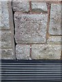
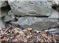
Ordnance Survey Cut Mark
This OS cut mark can be found on the NE face of Pendryn Garage. It marks a point 20.322m above mean sea level.
Image: © Adrian Dust
Taken: 8 May 2016
0.03 miles
2
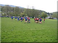
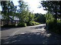
Cader Road, Dolgellau
Giving access to the uplands which lie between Cadair Idris and the Mawddach Estuary. This is the main route for accessing the mountain from the north.
Image: © Nigel Brown
Taken: 24 May 2017
0.04 miles
3
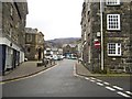
Eldon Square, Dolgellau
The town square in Dolgellau, Gwynedd on a gloomy Saturday.
Image: © Alex Martin
Taken: 26 Feb 2005
0.08 miles
4
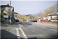
Road junction at the west of Dolgellau
Straight on for Tywyn, to the left for Cader.
Image: © John Lucas
Taken: 24 Mar 2022
0.09 miles
5
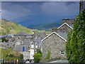
Dolgellau
Yn edrych i lawr Y Lawnt / Looking down Lombard Street
Image: © Ian Medcalf
Taken: 7 May 2012
0.12 miles
6
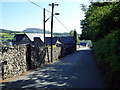
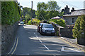
Road down to Dollgellau
The building on the left is Dolgellau Carmelite Monastery.
Image: © John Lucas
Taken: 26 May 2017
0.13 miles
7
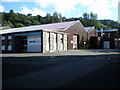
Nimbus Foods.
One of the first, and largest units on the estate is Nimbus Foods. http://www.nimbusfoods.co.uk/index.htm
Image: © Hefin Richards
Taken: 18 Jul 2007
0.13 miles
8
Ordnance Survey Cut Mark
This OS cut mark can be found on the wall of the Carmelite Monastery. It marks a point 50.457m above mean sea level.
Image: © Adrian Dust
Taken: 8 May 2016
0.14 miles
9
Looking down the estate road, Marian Mawr.
Looking towards RCH Cast Metal Signs http://www.rchsigns.com/
and Idris Contract Flooring. http://www.idriscontractflooring.co.uk/
Image: © Hefin Richards
Taken: 18 Jul 2007
0.15 miles