IMAGES TAKEN NEAR TO
Cae'r Dderwen, DOLGELLAU, LL40 1GE
Introduction
This page details the photographs taken nearby to Cae'r Dderwen, LL40 1GE by members of the Geograph project.
The Geograph project started in 2005 with the aim of publishing, organising and preserving representative images for every square kilometre of Great Britain, Ireland and the Isle of Man.

There are currently over 7.5m images from over14,400 individuals and you can help contribute to the project by visiting https://www.geograph.org.uk
Image Map
Images are licensed for reuse under creativecommons.org/licenses/by-sa/2.0
Notes
- Clicking on the map will re-center to the selected point.
- The higher the marker number, the further away the image location is from the centre of the postcode.
Image Listing (7 Images Found)
Images are licensed for reuse under creativecommons.org/licenses/by-sa/2.0
Image
Details
Distance
1
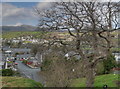
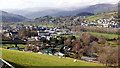
Wenallt, Dolgellau
The Wenallt area of Dolgellau from just above the Maesbrith housing estate.
Image: © Stephen Elwyn RODDICK
Taken: 15 Apr 2008
0.08 miles
2

Ordnance Survey Cut Mark
This OS cut mark can be found on the roadside barn at Plas-y-Brithdir. It marks a point 325.7ft above mean sea level.
Image: © Adrian Dust
Taken: 10 May 2018
0.10 miles
3
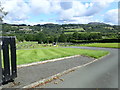
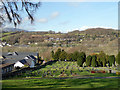
Dolgellau Cemetery
Looking down from Fron Serth
Image: © Eirian Evans
Taken: 13 Aug 2019
0.21 miles
4
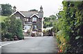
Entrance to Tanyfron camping/caravan site
Tanyfron (the house) also operated as a B&B
Image: © Mike Dodman
Taken: 1 Aug 1997
0.23 miles
5
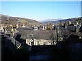
Across the rooftops towards Aran Fawddwy.
Image: © Hefin Richards
Taken: 3 Feb 2007
0.23 miles
6
Dolgellau ahead
Descending towards the town on cycle route 8 which I see also forms part of the Cross Britain Way.
Image: © John Lucas
Taken: 21 Feb 2019
0.24 miles
7
Dolgellau Cemetery
Viewed from cycle route 8 entering the town from the east.
Image: © John Lucas
Taken: 21 Feb 2019
0.25 miles