IMAGES TAKEN NEAR TO
Marian Road, DOLGELLAU, LL40 1DT
Introduction
This page details the photographs taken nearby to Marian Road, LL40 1DT by members of the Geograph project.
The Geograph project started in 2005 with the aim of publishing, organising and preserving representative images for every square kilometre of Great Britain, Ireland and the Isle of Man.

There are currently over 7.5m images from over14,400 individuals and you can help contribute to the project by visiting https://www.geograph.org.uk
Image Map
Images are licensed for reuse under creativecommons.org/licenses/by-sa/2.0
Notes
- Clicking on the map will re-center to the selected point.
- The higher the marker number, the further away the image location is from the centre of the postcode.
Image Listing (261 Images Found)
Images are licensed for reuse under creativecommons.org/licenses/by-sa/2.0
Image
Details
Distance
1
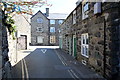
Marian Road, Dolgellau
Marian Road just to the south of St Mary's Church looking towards the junction with Lombard Street.
Image: © Jeff Buck
Taken: 22 Apr 2015
0.01 miles
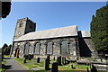
2
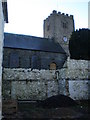
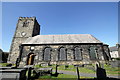
Rear view of St Mary's.
The present Church dates from 1716, with a chancel added in 1864. The masonry is, unusually, of dressed slate with blocks overlapping at the corners, log-cabin style. The timber piers inside were brought over the mountains by ox-cart from Dinas Mawddwy. A carved stone effigy (ca. 1350) of Meurig ap Ynyr Fychan lies in the NE corner of the church. The first mention of the church and indeed of "Dolkelew" is from 1253.
Image: © Hefin Richards
Taken: 3 Feb 2007
0.01 miles
3
Path to the Church
St. Mary's Church in Dolgellau.
Image: © DS Pugh
Taken: 31 Jul 2018
0.01 miles
4
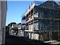
Renovation works .
These old building are presently undergoing thorough renovation works.
Image: © Hefin Richards
Taken: 3 Feb 2007
0.02 miles
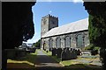
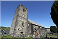
5
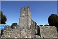
Eglwys y Santes Fair (St Mary's Church), Dolgellau
The original church in Dolgellau was built some time in the 12th century. It was demolished in 1716 when the present church was built.
* I used a wide angle lens to get the full length of the church in the photo (hence the leaning tower etc), impossible otherwise. So any Geograph purists who think these kind of photos should be rejected, take it up with your colleagues as I couldn't give a stuff. Wikipedia seem to think one of my photos of this church is good enough for the Dolgellau page. https://en.wikipedia.org/wiki/Dolgellau
Image: © Jeff Buck
Taken: 22 Apr 2015
0.02 miles
6
Eglwys y Santes Fair (St Mary's Church), Dolgellau
The original church in Dolgellau was built some time in the 12th century. It was demolished in 1716 when the present church was built.
Image: © Jeff Buck
Taken: 22 Apr 2015
0.02 miles
7
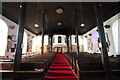
Interior of Eglwys y Santes Fair (St Mary's Church), Dolgellau
Looking west along the nave. The original church in Dolgellau was built some time in the 12th century. It was demolished in 1716 when the present church was built.
Image: © Jeff Buck
Taken: 22 Apr 2015
0.02 miles
8
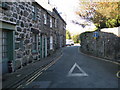
Ffordd y Marian - Marian Rd.
Once a prosperous area with many little shops, one can be seen on the left of shot.
Image: © Hefin Richards
Taken: 3 Feb 2007
0.02 miles
9
Eglwys y Santes Fair (St Mary's Church), Dolgellau
The original church in Dolgellau was built some time in the 12th century. It was demolished in 1716 when the present church was built.
Image: © Jeff Buck
Taken: 22 Apr 2015
0.02 miles
10
Eglwys y Santes Fair (St Mary's Church), Dolgellau
The original church in Dolgellau was built some time in the 12th century. It was demolished in 1716 when the present church was built.
* I used a wide angle lens to get the full length of the church in the photo (hence the leaning tower etc), impossible otherwise. So any Geograph purists who think these kind of photos should be rejected, take it up with your colleagues as I couldn't give a stuff. Wikipedia seem to think one of my photos of this church is good enough for the Dolgellau page. https://en.wikipedia.org/wiki/Dolgellau
Image: © Jeff Buck
Taken: 22 Apr 2015
0.02 miles