IMAGES TAKEN NEAR TO
FAIRBOURNE, LL38 2HJ
Introduction
This page details the photographs taken nearby to LL38 2HJ by members of the Geograph project.
The Geograph project started in 2005 with the aim of publishing, organising and preserving representative images for every square kilometre of Great Britain, Ireland and the Isle of Man.

There are currently over 7.5m images from over14,400 individuals and you can help contribute to the project by visiting https://www.geograph.org.uk
Image Map
Images are licensed for reuse under creativecommons.org/licenses/by-sa/2.0
Notes
- Clicking on the map will re-center to the selected point.
- The higher the marker number, the further away the image location is from the centre of the postcode.
Image Listing (6 Images Found)
Images are licensed for reuse under creativecommons.org/licenses/by-sa/2.0
Image
Details
Distance
1
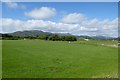
Farmland beside the A493
Looking across towards Barmouth.
Image: © DS Pugh
Taken: 19 Jul 2015
0.09 miles
2
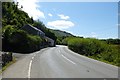
A493 near Fairbourne
Passing houses on the A493 near Fairbourne.
Image: © DS Pugh
Taken: 19 Jul 2015
0.14 miles
3
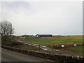
Bwlchgwyn Farm
A traditional sheep and cattle farm which has diversified to provide holiday cottages, camp site and pony trekking.
Image: © Eirian Evans
Taken: 19 Mar 2019
0.21 miles
4
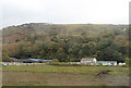
Across the fields to Bwlchgwyn
From the railway
Image: © John Firth
Taken: 23 Oct 2012
0.23 miles
5
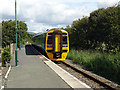
Departing from Fairbourne
A train running from Birmingham International to Pwllheli departs after a stop at Fairbourne.
Cambrian unit 158823.
Image: © John Lucas
Taken: 24 Aug 2016
0.24 miles
6
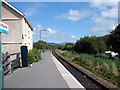
On Fairbourne station platform
Fairbourne only ever had a single platform but there appears to have been provision for a second that never materialised. It did have a single road goods yard (to the left of the fencing beyond the building) and there was a tramway running through the yard, serving a nearby brickworks.
Image: © John Lucas
Taken: 8 Aug 2006
0.25 miles