IMAGES TAKEN NEAR TO
Godre'r Gaer, LLWYNGWRIL, LL37 2JZ
Introduction
This page details the photographs taken nearby to Godre'r Gaer, LL37 2JZ by members of the Geograph project.
The Geograph project started in 2005 with the aim of publishing, organising and preserving representative images for every square kilometre of Great Britain, Ireland and the Isle of Man.

There are currently over 7.5m images from over14,400 individuals and you can help contribute to the project by visiting https://www.geograph.org.uk
Image Map (Loading...)


Getting Data...Please wait
Leaflet Map data © OpenStreetMap
Images are licensed for reuse under creativecommons.org/licenses/by-sa/2.0
Notes
- Clicking on the map will re-center to the selected point.
- The higher the marker number, the further away the image location is from the centre of the postcode.
Image Listing (57 Images Found)
Images are licensed for reuse under creativecommons.org/licenses/by-sa/2.0
Image
Details
Distance
1
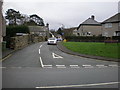
Road leading into Godre'r Gaer estate.
Image: © Hefin Richards
Taken: 16 Jan 2007
0.01 miles
2
Godre'r Gaer bus stop, Llwyngwril
At the southern end of the village.
Image: © Eirian Evans
Taken: 19 Mar 2019
0.03 miles
3
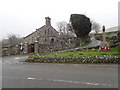
St Celynnin's Church, Llwyngwril
The church of St Celynin is situated at the south end of the village, in a rectangular churchyard used as a cemetery, set back from the main road just north of its junction with a minor road. It was built in 1841-3 to designs of Thomas Jones of Chester to replace the isolated Llangelynin church Image The village war memorial is located on the east side of the A493 road outside the church in what appears to be a small enclosed extension of the church graveyard.
Image: © Eirian Evans
Taken: 19 Mar 2019
0.04 miles
4
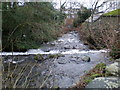
Weir in River Gwril
The weir was part of the abstraction process for two, possibly three mills lower down in the village.
Image: © Hefin Richards
Taken: 16 Jan 2007
0.05 miles
5
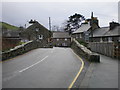
Pont Gwril viewed from the Northern end.
Image: © Hefin Richards
Taken: 16 Jan 2007
0.05 miles
6
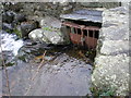
Sluice gate at Gwril weir.
The handwheel has long since been removed to stop kids ( ahem ;-) ) from opening the gate.
Image: © Hefin Richards
Taken: 16 Jan 2007
0.05 miles
7
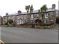
Row of stone cottages on the main road at Llwyngwril
Image: © Eirian Evans
Taken: 19 Mar 2019
0.06 miles
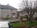
8
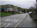
Godre'r Gaer and road leading into Llwyngwril.
Godre'r Gaer is the council house estate seen on the left in the shadow of "Y Gaer", the hill seen behind it that had the hill fort Castell y Gaer at its summit.
Image: © Hefin Richards
Taken: 16 Jan 2007
0.06 miles
9
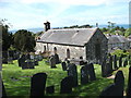
Eglwys Sant Celynin, Llwyngwril
Stone church on southern edge of the village.
Image: © John Haynes
Taken: 16 May 2012
0.06 miles
10
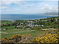
Looking towards Llwyngwril
The village spread out below Castell-y-Gaer. Standing in the circle of the Iron Age hill fort you appreciate why this defensive site was chosen.
http://www.coflein.gov.uk/en/site/302716/details/CASTELL-Y-GAER/
Image: © John Haynes
Taken: 16 May 2012
0.06 miles