IMAGES TAKEN NEAR TO
Llanfihangel Y Pennant, TYWYN, LL36 9TN
Introduction
This page details the photographs taken nearby to LL36 9TN by members of the Geograph project.
The Geograph project started in 2005 with the aim of publishing, organising and preserving representative images for every square kilometre of Great Britain, Ireland and the Isle of Man.

There are currently over 7.5m images from over14,400 individuals and you can help contribute to the project by visiting https://www.geograph.org.uk
Image Map
Images are licensed for reuse under creativecommons.org/licenses/by-sa/2.0
Notes
- Clicking on the map will re-center to the selected point.
- The higher the marker number, the further away the image location is from the centre of the postcode.
Image Listing (13 Images Found)
Images are licensed for reuse under creativecommons.org/licenses/by-sa/2.0
Image
Details
Distance
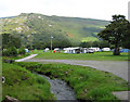
3
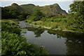
Afon Dysynni and Birds' Rock
View of Afon Dysynni and Birds' Rock from the campsite at Llanllwyda Farm.
Image: © Philip Halling
Taken: 6 Jul 2010
0.11 miles
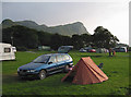
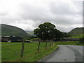
8
Dysynni Valley
The floor of the Dysynni valley viewed from the campsite at Llanllwyda.
Image: © Philip Halling
Taken: 6 Jul 2010
0.16 miles
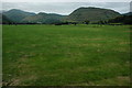
9
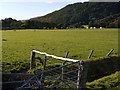
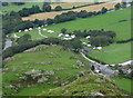
Field near Ty'n-y-ffordd cottage
Flat grazing on the valley floor; one of many drainage ditches can be seen in the foreground. Llanllwyda campsite can be seen beyond.
Image: © Nigel Brown
Taken: 21 Oct 2010
0.18 miles
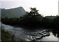
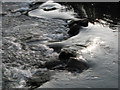
10
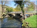
Pont Llanllwyda Bridge
Pont yn rhychwantu Afon Dysynni ger Ffarm Llanllwyda. Ma'e heol wedi ei hisraddio i gilffordd .
A bridge spanning the Dysynni River near Llanllwyda Farm. The road had been downgraded to a byway.
Image: © Alan Richards
Taken: 7 May 2013
0.19 miles