IMAGES TAKEN NEAR TO
Dolwen, TYWYN, LL36 9NY
Introduction
This page details the photographs taken nearby to Dolwen, LL36 9NY by members of the Geograph project.
The Geograph project started in 2005 with the aim of publishing, organising and preserving representative images for every square kilometre of Great Britain, Ireland and the Isle of Man.

There are currently over 7.5m images from over14,400 individuals and you can help contribute to the project by visiting https://www.geograph.org.uk
Image Map (Loading...)


Getting Data...Please wait
Leaflet Map data © OpenStreetMap
Images are licensed for reuse under creativecommons.org/licenses/by-sa/2.0
Notes
- Clicking on the map will re-center to the selected point.
- The higher the marker number, the further away the image location is from the centre of the postcode.
Image Listing (22 Images Found)
Images are licensed for reuse under creativecommons.org/licenses/by-sa/2.0
Image
Details
Distance
2
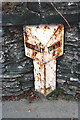
Old Milepost by the A493, south of Bryncrug Bridge, Bryncrug Parish
By the A493, in parish of Bryncrug (Gwynedd District), South of Bryncrug Bridge, Bryncrug, built into wall on West side of road, opposite bus stop, South of Afon Fathew bridge.
Inscription reads:-
: DOLGELLEY / 17 : : TOWYN / 2 :
Grade II listed by Cadw. Reference Number: 23895
https://cadwpublic-api.azurewebsites.net/reports/listedbuilding/FullReport?lang=&id=23895
Surveyed
Milestone Society National ID: MER_TWDGa02
Image: © Milestone Society
Taken: Unknown
0.05 miles
3

Bryncrug Village
Looking down towards the village.
Image: © Ben Nock
Taken: 19 Oct 2007
0.06 miles
4
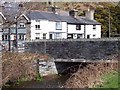
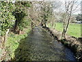
Bridge at Bryncrug
Bridge taking the A493 road over the river at Bryncrug.
Image: © Cered
Taken: 8 Apr 2006
0.06 miles
6
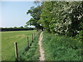
Llwybr Arfordir Cymru
The Wales Coast Path heading west going south leaves Bryncrug.
http://www.ccw.gov.uk/enjoying-the-country/wales-coast-path.aspx?lang=en
http://www.ccgc.gov.uk/enjoying-the-country/wales-coast-path.aspx?lang=cy-gb
Image: © John Haynes
Taken: 25 May 2012
0.07 miles
8
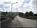
The A493 road running through Bryncrug
The minor road on the right connects with the B4405 road which leads to Llyn Tal-y-llyn.
Image: © John Lucas
Taken: 26 May 2016
0.08 miles
9

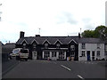
Bryncrug Village Store
Now closed, just selling logs.
Image: © Eirian Evans
Taken: 26 Mar 2019
0.08 miles
10
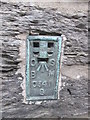
Ordnance Survey Flush Bracket (S0341)
This OS Flush Bracket can be found on the south face of Pontfethen House. It marks a point 7.279m above mean sea level.
Image: © Adrian Dust
Taken: 26 Jul 2015
0.08 miles