IMAGES TAKEN NEAR TO
Rhoslefain, TYWYN, LL36 9NA
Introduction
This page details the photographs taken nearby to LL36 9NA by members of the Geograph project.
The Geograph project started in 2005 with the aim of publishing, organising and preserving representative images for every square kilometre of Great Britain, Ireland and the Isle of Man.

There are currently over 7.5m images from over14,400 individuals and you can help contribute to the project by visiting https://www.geograph.org.uk
Image Map (Loading...)


Getting Data...Please wait
Leaflet Map data © OpenStreetMap
Images are licensed for reuse under creativecommons.org/licenses/by-sa/2.0
Notes
- Clicking on the map will re-center to the selected point.
- The higher the marker number, the further away the image location is from the centre of the postcode.
Image Listing (15 Images Found)
Images are licensed for reuse under creativecommons.org/licenses/by-sa/2.0
Image
Details
Distance
1
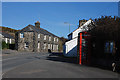
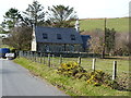
Houses and telephone box, Rhoslefain
Situated at the junction of several minor roads with the A493 main road, the village is a mixture of older houses like these together with a group of council houses.
Image: © Nigel Brown
Taken: 4 Mar 2010
0.01 miles
2
Bwthyn Cae Coed
On the main road at Rhoslefain
Image: © Eirian Evans
Taken: 19 Mar 2019
0.02 miles
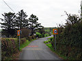
3
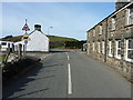
The centre of Rhoslefain village
Not the busiest road I've ever stood in!
Image: © Richard Law
Taken: 4 Mar 2014
0.02 miles
4
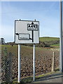
Traditional road sign in Rhoslefain
To the left for Tonfanau and straight on for 'Dollgelley' (Dollgellau). A surprise that the sign escaped the attentions of the Welsh Language Society in the sixties and seventies!
Image: © John Lucas
Taken: 19 Oct 2015
0.04 miles
6
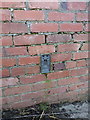
OS Flush Bracket 10910
Flush Bracket 10910 in the NW gable of a cowshed at Rhoslefain Farm; originally levelled at 64.195m above Ordnance Datum Newlyn.
Image: © Richard Law
Taken: 4 Mar 2014
0.07 miles
8
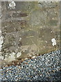
OS benchmark - Rhoslefain, St Mary's chapel
A neat OS cutmark on the gable wall of the former chapel in Rhoslefain; originally levelled at 63.24m above Ordnance Datum Newlyn.
Image: © Richard Law
Taken: 4 Mar 2014
0.11 miles
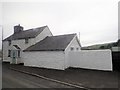
9
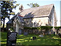
St Mary's chapel, Rhoslefain
A small village chapel, now de-dedicated and in the course of conversion to a holiday let. The Image on the SE gable wall remains, despite all the repointing work that's taken place.
Image: © Richard Law
Taken: 4 Mar 2014
0.12 miles
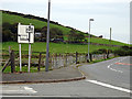
10
Entering Rhoslefain
Using a shortcut through the village while walking the Wales Coast path from Tonfanau to Llwyngwril.
Image: © John Lucas
Taken: 19 Oct 2015
0.15 miles