IMAGES TAKEN NEAR TO
Rhoslefain, TYWYN, LL36 9LS
Introduction
This page details the photographs taken nearby to LL36 9LS by members of the Geograph project.
The Geograph project started in 2005 with the aim of publishing, organising and preserving representative images for every square kilometre of Great Britain, Ireland and the Isle of Man.

There are currently over 7.5m images from over14,400 individuals and you can help contribute to the project by visiting https://www.geograph.org.uk
Image Map (Loading...)


Getting Data...Please wait
Leaflet Map data © OpenStreetMap
Images are licensed for reuse under creativecommons.org/licenses/by-sa/2.0
Notes
- Clicking on the map will re-center to the selected point.
- The higher the marker number, the further away the image location is from the centre of the postcode.
Image Listing (17 Images Found)
Images are licensed for reuse under creativecommons.org/licenses/by-sa/2.0
Image
Details
Distance
1
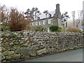
Llanfendigaid
Mid C18 estate house, presumed to be on the site of a much earlier house. It is Grade II* listed and is now in use, along with other farm buildings, as holiday accommodation.
Image: © Eirian Evans
Taken: 19 Mar 2019
0.01 miles
2
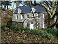
Llanfendigaid Hall
A frontal view from the road of the magnificent Llanfendigaid Hall, more details of the building at Image
Image: © Richard Law
Taken: 4 Mar 2014
0.01 miles
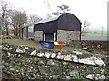
3
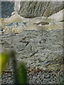
OS benchmark - Llanfendigaid barn
An OS cutmark on the gable end of an outbuilding at Llanfendigaid Hall; originally levelled at 30.956m above Ordnance Datum Newlyn.
Image: © Richard Law
Taken: 4 Mar 2014
0.02 miles
4
Llanfendigaid Hall
This view of the mansion shows its structure. The front of the house faces left towards Tonfanau and the service part extends to the right. Note the dining rooms three windows on the ground floor. This building, dated 1745, is available for holiday lets.
Image: © Mike White
Taken: 21 Nov 2008
0.03 miles
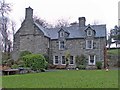
6
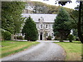
Llanfendigaid Hall.
Shame about the Leylandii!
Image: © Hefin Richards
Taken: 13 Sep 2006
0.06 miles
7
Welsh daffodils in rough ground near Llanfendigaid
A small patch of daffs heralds the possible arrival of spring under the shelter of a copse of trees. Lambs in the fields are another good sign.
Image: © Richard Law
Taken: 4 Mar 2014
0.10 miles
8
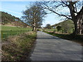
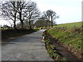
The lane into Rhoslefain
The coastal road that once ran from Tywyn to Rhoslefain; the bridge over the Dysynni is now closed to vehicles, so the main A493 takes the traffic instead.
Image: © Richard Law
Taken: 4 Mar 2014
0.12 miles
9
Council ditch clearance work at Llanfendigaid
Excellent work in progress, and much needed after the UK's wettest winter on record.
Image: © Richard Law
Taken: 4 Mar 2014
0.16 miles
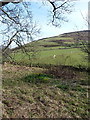
10
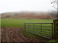
South-western slopes of Moel Llanfendigaid
At 132m, it is the 17314th highest peak in the British Isles!
Image: © Eirian Evans
Taken: 19 Mar 2019
0.17 miles