IMAGES TAKEN NEAR TO
Bryn Heulog, TYWYN, LL36 9DY
Introduction
This page details the photographs taken nearby to Bryn Heulog, LL36 9DY by members of the Geograph project.
The Geograph project started in 2005 with the aim of publishing, organising and preserving representative images for every square kilometre of Great Britain, Ireland and the Isle of Man.

There are currently over 7.5m images from over14,400 individuals and you can help contribute to the project by visiting https://www.geograph.org.uk
Image Map (Loading...)


Getting Data...Please wait
Leaflet Map data © OpenStreetMap
Images are licensed for reuse under creativecommons.org/licenses/by-sa/2.0
Notes
- Clicking on the map will re-center to the selected point.
- The higher the marker number, the further away the image location is from the centre of the postcode.
Image Listing (281 Images Found)
Images are licensed for reuse under creativecommons.org/licenses/by-sa/2.0
Image
Details
Distance
1
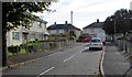
Brynheulog, Tywyn
From the corner of Faenor Avenue.
Image: © Jaggery
Taken: 22 Oct 2016
0.01 miles
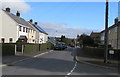
2
Faenol Avenue, Tywyn
At the fork in the road ahead, Faenol Avenue continues on the left, Brynheulog is on the right.
Image: © Jaggery
Taken: 22 Oct 2016
0.04 miles
3
From Faenol Avenue to Brynheulog, Tywyn
The sign on the left shows RHODFA FAENOL AVENUE (a typical Tywyn way of representing the Welsh RHODFA FAENOL and the English FAENOL AVENUE). The Brynheulog sign is behind the tree.
Image: © Jaggery
Taken: 22 Oct 2016
0.04 miles
4
Faenol Avenue, Tywyn
From the corner of Brynheulog.
Image: © Jaggery
Taken: 22 Oct 2016
0.05 miles
5
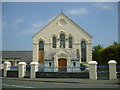
Welsh Presbyterian Church at Tywyn
The Eglwys Bresbyteraidd Cymru looks well maintained from the front, despite the boarded up window. However, the hall attached to its side has received much less care.
Image: © William Metcalfe
Taken: 5 May 2007
0.06 miles
6
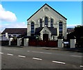
Capel Bethel Newydd, Tywyn
Welsh Presbyterian chapel viewed from Neptune Road. The nameboard is in Welsh only. http://www.geograph.org.uk/photo/5171448
Image: © Jaggery
Taken: 22 Oct 2016
0.06 miles
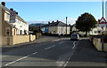
7
Western end of Ffordd Alban, Tywyn
Looking east across Neptune Road.
Image: © Jaggery
Taken: 22 Oct 2016
0.06 miles
8
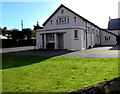
Former Bethel Methodist Chapel, Neptune Road, Tywyn
This is the 1871 rebuild of the original chapel of 1815. The present-day chapel is in this http://www.geograph.org.uk/photo/5171446 adjacent building.
Image: © Jaggery
Taken: 22 Oct 2016
0.07 miles
9
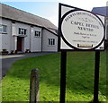
Welsh-only chapel nameboard facing Neptune Road, Tywyn
Outside Capel Bethel Newydd. http://www.geograph.org.uk/photo/5171446
Image: © Jaggery
Taken: 22 Oct 2016
0.07 miles
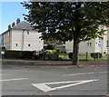
10
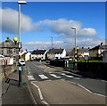
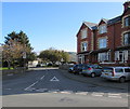
Zebra crossing, Neptune Road, Tywyn
Each Belisha beacon is halfway up a lamppost.
The entrance to Capel Bethel Newydd http://www.geograph.org.uk/photo/5171446 is on the right.
Image: © Jaggery
Taken: 22 Oct 2016
0.07 miles