IMAGES TAKEN NEAR TO
Outward Bound Bungalows, ABERDOVEY, LL35 0RP
Introduction
This page details the photographs taken nearby to Outward Bound Bungalows, LL35 0RP by members of the Geograph project.
The Geograph project started in 2005 with the aim of publishing, organising and preserving representative images for every square kilometre of Great Britain, Ireland and the Isle of Man.

There are currently over 7.5m images from over14,400 individuals and you can help contribute to the project by visiting https://www.geograph.org.uk
Image Map (Loading...)


Getting Data...Please wait
Leaflet Map data © OpenStreetMap
Images are licensed for reuse under creativecommons.org/licenses/by-sa/2.0
Notes
- Clicking on the map will re-center to the selected point.
- The higher the marker number, the further away the image location is from the centre of the postcode.
Image Listing (18 Images Found)
Images are licensed for reuse under creativecommons.org/licenses/by-sa/2.0
Image
Details
Distance
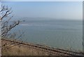
2

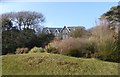
The Outward Bound Trust
Entrance to the Aberdyfi Centre, where adventurous and challenging outdoor learning courses are run that equip young people with valuable skills for education, work and life.
Image: © Eirian Evans
Taken: 18 Mar 2016
0.07 miles
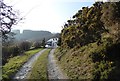
5
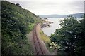
Railway up the estuary
Looking away from Aberdovey, up the Cambrian Coast line towards the Image at Trefri.
Image: © Richard Law
Taken: 13 Feb 2016
0.09 miles
6
Picnic Island Penhelig
View from footbridge to island
Image: © norman griffin
Taken: 15 Jul 1997
0.10 miles
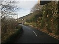
7
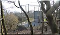
Exercise area at the Aberdyfi Centre of the Outward Bound Trust
Image: © Eirian Evans
Taken: 18 Mar 2016
0.10 miles
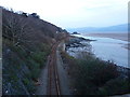
8
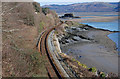
Cambrian Coast Railway
The railway connects Pwllheli to Aberystwyth. Here it is heading east beside the Dyfi estuary. The little island in the distance belongs to Trefri Hall and is attached to the mainland by a castellated walkway and bridge which leads across to the island which is a wooded rocky outcrop with pathways leading round to the castellated folly to the Western end.
Image: © Eirian Evans
Taken: 18 Mar 2016
0.11 miles
9
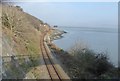
The Cambrian coast line east of Penhelig
Winding its way along the Dyfi estuary.
Image: © Nigel Brown
Taken: 11 Feb 2010
0.12 miles
10
The Dyfi Estuary
Looking across the Cambrian Railway Line and the wide estuary, this is the area of the Dyfi Nature Reserve
Image: © Eirian Evans
Taken: 18 Mar 2016
0.13 miles