IMAGES TAKEN NEAR TO
Philip Avenue, ABERDOVEY, LL35 0PY
Introduction
This page details the photographs taken nearby to Philip Avenue, LL35 0PY by members of the Geograph project.
The Geograph project started in 2005 with the aim of publishing, organising and preserving representative images for every square kilometre of Great Britain, Ireland and the Isle of Man.

There are currently over 7.5m images from over14,400 individuals and you can help contribute to the project by visiting https://www.geograph.org.uk
Image Map (Loading...)


Getting Data...Please wait
Leaflet Map data © OpenStreetMap
Images are licensed for reuse under creativecommons.org/licenses/by-sa/2.0
Notes
- Clicking on the map will re-center to the selected point.
- The higher the marker number, the further away the image location is from the centre of the postcode.
Image Listing (41 Images Found)
Images are licensed for reuse under creativecommons.org/licenses/by-sa/2.0
Image
Details
Distance
1
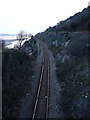
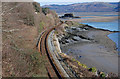
Railway towards Aberdovey
A stretch of the Cambrian Coast Railway, here heading alongside the Dyfi estuary into Aberdovey from the Machynlleth direction.
Image: © Richard Law
Taken: 13 Feb 2016
0.03 miles
2
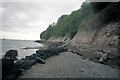
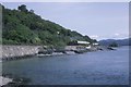
Penhelig Picnic Island
Beach and steps below the island
Image: © norman griffin
Taken: 15 Jul 1997
0.04 miles
3
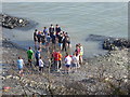
Students from the Outward Bound Centre
An activity by the Dyfi by students from the nearby Outward Bound Centre
Image: © Eirian Evans
Taken: 18 Mar 2016
0.05 miles
4
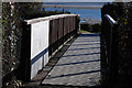
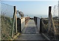
Footbridge to Picnic Island
Giving public access to the foreshore on the other side of the railway.
Image: © Nigel Brown
Taken: 11 Feb 2010
0.05 miles
5
Footbridge over the railway
The footbridge leads to a small picnic area overlooking the Dyfi estuary
Image: © Eirian Evans
Taken: 18 Mar 2016
0.07 miles
6
Manor on the Cambrian
7819 Hinton Manor skirts the coastline in the morning sun nr Penhelig.
Image: © roger geach
Taken: 17 Aug 1987
0.10 miles
7
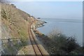
The Cambrian coast line east of Penhelig
Winding its way along the Dyfi estuary.
Image: © Nigel Brown
Taken: 11 Feb 2010
0.10 miles
8
Cambrian Coast Railway
The railway connects Pwllheli to Aberystwyth. Here it is heading east beside the Dyfi estuary. The little island in the distance belongs to Trefri Hall and is attached to the mainland by a castellated walkway and bridge which leads across to the island which is a wooded rocky outcrop with pathways leading round to the castellated folly to the Western end.
Image: © Eirian Evans
Taken: 18 Mar 2016
0.11 miles
9
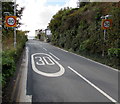
Start of the 30 zone at the eastern edge of Aberdovey
The 40mph speed limit on the A493 drops to 30mph.
Image: © Jaggery
Taken: 17 Oct 2016
0.11 miles
10
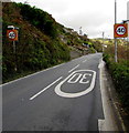
End of the 30 zone at the eastern edge of Aberdovey
The 30mph speed limit on the A493 increases to 40mph.
Image: © Jaggery
Taken: 17 Oct 2016
0.11 miles