IMAGES TAKEN NEAR TO
ABERDOVEY, LL35 0PF
Introduction
This page details the photographs taken nearby to LL35 0PF by members of the Geograph project.
The Geograph project started in 2005 with the aim of publishing, organising and preserving representative images for every square kilometre of Great Britain, Ireland and the Isle of Man.

There are currently over 7.5m images from over14,400 individuals and you can help contribute to the project by visiting https://www.geograph.org.uk
Image Map (Loading...)


Getting Data...Please wait
Leaflet Map data © OpenStreetMap
Images are licensed for reuse under creativecommons.org/licenses/by-sa/2.0
Notes
- Clicking on the map will re-center to the selected point.
- The higher the marker number, the further away the image location is from the centre of the postcode.
Image Listing (5 Images Found)
Images are licensed for reuse under creativecommons.org/licenses/by-sa/2.0
Image
Details
Distance
1
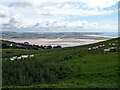
Grazing by Mynydd Bychan
Above Aberdyfi, which is hidden by the landscape, but with the sand dunes of Ynyslas visible across the Dyfi Estuary.
Image: © John Lucas
Taken: 5 Jul 2016
0.09 miles
2
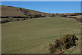
Fields above Aberdyfi
Good grazing on the hill.
Image: © Nigel Brown
Taken: 11 Feb 2010
0.14 miles
4
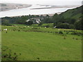
Cae mawr ger Erw-Gwenllian / Large field near Erw-Gwenllian
Golygfa dros y cae tuag at Moryd y Ddyfi ac Ynyslas / A view over the field to the Dyfi Estuary and Ynyslas.
Image: © Ian Medcalf
Taken: 9 Jul 2011
0.22 miles
5

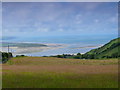
Sunshine in northern Wales
The sunshine picked out this area in the distance across Cardigan Bay, need a compass bearing to identify it correctly, but my guess is Towyn near Aberdovey?
Image: © chris whitehouse
Taken: 10 Nov 2012
0.24 miles