IMAGES TAKEN NEAR TO
PENMAENMAWR, LL34 6YR
Introduction
This page details the photographs taken nearby to LL34 6YR by members of the Geograph project.
The Geograph project started in 2005 with the aim of publishing, organising and preserving representative images for every square kilometre of Great Britain, Ireland and the Isle of Man.

There are currently over 7.5m images from over14,400 individuals and you can help contribute to the project by visiting https://www.geograph.org.uk
Image Map
Images are licensed for reuse under creativecommons.org/licenses/by-sa/2.0
Notes
- Clicking on the map will re-center to the selected point.
- The higher the marker number, the further away the image location is from the centre of the postcode.
Image Listing (3 Images Found)
Images are licensed for reuse under creativecommons.org/licenses/by-sa/2.0
Image
Details
Distance
1
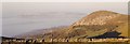
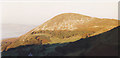
View north towards Foel Lus
This image was taken from the North Wales Coastal Path. The Great Orme can be seen in the background.
Image: © Eric Jones
Taken: 13 Oct 1997
0.25 miles
3

Interesting signage
The sign is on nice stone, but doesn't seem to be local stone which is strange in this area of quarries. What happens if/when the café at Capelulo closes? It is a long, and not very obvious, way to Llangelynin. The Huw Tom trail is described here: https://tinyurl.com/yb2gw6z6
Image: © David Medcalf
Taken: 25 Nov 2018
0.25 miles