IMAGES TAKEN NEAR TO
Gwel Y Mor, PENMAENMAWR, LL34 6SB
Introduction
This page details the photographs taken nearby to Gwel Y Mor, LL34 6SB by members of the Geograph project.
The Geograph project started in 2005 with the aim of publishing, organising and preserving representative images for every square kilometre of Great Britain, Ireland and the Isle of Man.

There are currently over 7.5m images from over14,400 individuals and you can help contribute to the project by visiting https://www.geograph.org.uk
Image Map (Loading...)


Getting Data...Please wait
Leaflet Map data © OpenStreetMap
Images are licensed for reuse under creativecommons.org/licenses/by-sa/2.0
Notes
- Clicking on the map will re-center to the selected point.
- The higher the marker number, the further away the image location is from the centre of the postcode.
Image Listing (61 Images Found)
Images are licensed for reuse under creativecommons.org/licenses/by-sa/2.0
Image
Details
Distance
1
Looking inland
Looking inland from the footpath near the Puffin Service station and Cafe towards the village of Dwygyfylch. You can just see the houses on the edge of the village.
Image: © Malcolm Neal
Taken: 15 Aug 2017
0.05 miles
2
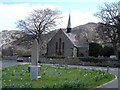
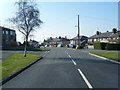
Dwygyfylchi
Village centre at Dwygyfylchi
Image: © Dot Potter
Taken: 17 Apr 2006
0.06 miles
3
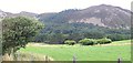
Pasture Land
This image is taken from SH734776 looking inland (east) across the local pasture. The sizeable lump of rock in the distance is Altwen.
Image: © Dave Smethurst
Taken: 13 Aug 2005
0.06 miles
4
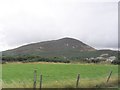
View of Foel Lus
This image shows Foel Lus (362m) which sits between the towns of Penmaenmawr and Dwygyfylchi. Although this image was taken from SH7377 looking south it was submitted as it shows the hill in all its glory which would not have been possible from a closer perspective.
Image: © Dave Smethurst
Taken: 13 Aug 2005
0.06 miles
5
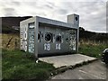
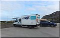
A new spin on an old theme
Revolution 18 kg - a drive in 24/7 launderette.
Positioned in a car park. Wash and watch your smalls on a small screen.
Image: © Richard Hoare
Taken: 15 Oct 2019
0.09 miles
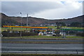
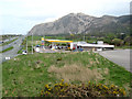
7
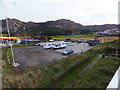
Puffin car park off A55 North Wales Expressway
The spin and rinse is on site. Image]
The flag poles to the left do actually lean - it is not a quirk of the camera.
Image: © Richard Hoare
Taken: 15 Oct 2019
0.11 miles
8
Van Dijk Expresse at the Puffin garage
A Netherlands based trucking firm certified for temperature critical transport of pharmaceutical products.
Image: © Richard Hoare
Taken: 15 Oct 2019
0.11 miles
9
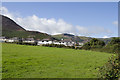
Dwygyfylchi services
The petrol station and erstwhile Little Chef restaurant by the side of the A55 Expressway, imaged from the footbridge carrying the footpath to the beach. Although many of the Little Chef restaurants were saved under the re-financing following administration in late 2006, this was not one of them and the site remains in a derelict condition. The car park used to be very useful for forays to the beach, but access is now blocked.
In the background the great, scree-covered mass of the Penmaenbach shows its igneous origins wonderfully.
Image: © Jonathan Wilkins
Taken: 16 Apr 2011
0.11 miles