IMAGES TAKEN NEAR TO
Gilfach Road, PENMAENMAWR, LL34 6HW
Introduction
This page details the photographs taken nearby to Gilfach Road, LL34 6HW by members of the Geograph project.
The Geograph project started in 2005 with the aim of publishing, organising and preserving representative images for every square kilometre of Great Britain, Ireland and the Isle of Man.

There are currently over 7.5m images from over14,400 individuals and you can help contribute to the project by visiting https://www.geograph.org.uk
Image Map
Images are licensed for reuse under creativecommons.org/licenses/by-sa/2.0
Notes
- Clicking on the map will re-center to the selected point.
- The higher the marker number, the further away the image location is from the centre of the postcode.
Image Listing (49 Images Found)
Images are licensed for reuse under creativecommons.org/licenses/by-sa/2.0
Image
Details
Distance
1
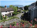
View from Bell Yard
The establishment of Penmaenmawr quarry was very closely integrated with the town until relatively recently. At this point the old incline and subsequent conveyors passed behind the manager's house at Bell Yard on the way down to sea level. A derelict supporting pier survives amid the burgeoning Valerian which thrives on the old walls.
Image: © Jonathan Wilkins
Taken: 23 Jun 2016
0.03 miles
2
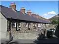
Rear of Erasmus Street
The steep terrain makes construction difficult! These stone-built terraces were originally constructed for the quarry workers at a time when that was the only industry in the town. This is a view of the backs, more interesting than the front, but possibly less flattering.
Image: © Jonathan Wilkins
Taken: 21 Aug 2009
0.09 miles
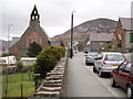
3
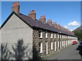
Front of David Street
The south-facing, odd-numbered side of David Street, showing the neatly-built stone terrace. The camber on the road is extreme, as indicated by the red van.
Image: © Jonathan Wilkins
Taken: 21 Aug 2009
0.10 miles
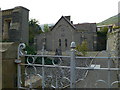
5
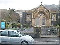
The preserved entrance to the former Berth Chapel
The main building has been demolished but interdenominational Welsh services are held in the former vestry to the rear. The chapel is now known as Eglwys y Berth ("bush church"). The Graig Lwyd granite quarry can be seen on the mountain above.
Image: © Eric Jones
Taken: 26 Mar 2010
0.10 miles
6
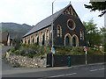
Penmaenmawr chapel
Disused chapel on Bangor Road, now up for sale.
Image: © Eirian Evans
Taken: 24 Apr 2009
0.10 miles
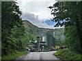
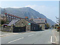
10
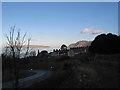
Afternoon shadows
Penmaenmawr is afforded deep shade by the high, steep hills to the south, so the sun does not shine in Winter. Brilliant illumination in Conwy Bay gives good contrast against the chimneys of nearby terraces, while the Great Orme appears to float in the sky which is reflected in the still sea. The road leads up to the quarry's weighbridge.
Image: © Jonathan Wilkins
Taken: 13 Jan 2012
0.13 miles