IMAGES TAKEN NEAR TO
Graiglwyd Road, PENMAENMAWR, LL34 6ER
Introduction
This page details the photographs taken nearby to Graiglwyd Road, LL34 6ER by members of the Geograph project.
The Geograph project started in 2005 with the aim of publishing, organising and preserving representative images for every square kilometre of Great Britain, Ireland and the Isle of Man.

There are currently over 7.5m images from over14,400 individuals and you can help contribute to the project by visiting https://www.geograph.org.uk
Image Map
Images are licensed for reuse under creativecommons.org/licenses/by-sa/2.0
Notes
- Clicking on the map will re-center to the selected point.
- The higher the marker number, the further away the image location is from the centre of the postcode.
Image Listing (22 Images Found)
Images are licensed for reuse under creativecommons.org/licenses/by-sa/2.0
Image
Details
Distance
1
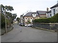
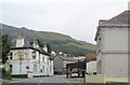
Graiglwyd Road 1
A view of older and varied buildings on this interesting road high on the slope above the town. It is notable for the grand, stone walls, built with the local igneous rock which is of a fine grain and medium grey colour.
Image: © Jonathan Wilkins
Taken: 26 Feb 2016
0.05 miles
2
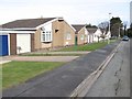
Merton park
Part of a larger development of rather uncharacteristic single and two-storey buildings which terrace down the steep hillside.
Image: © Jonathan Wilkins
Taken: 26 Feb 2016
0.08 miles
4
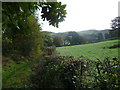
Footpath towards Graiglwyd
A footpath leading gently uphill towards Graiglwyd from Penmaenmawr.
Image: © Jeremy Bolwell
Taken: 13 Oct 2011
0.16 miles
5
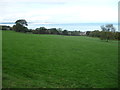
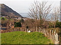
View over Pen-y-Coed and Penmaenmawr
The fields slope down towards the housing and offer good views towards the coast and sea and Puffin Island.
Image: © Jeremy Bolwell
Taken: 13 Oct 2011
0.21 miles
6
Penmaenmawr Museum
The museum is housed in the Old Post Office on Conway Old Road. https://www.penmaenmawrmuseum.co.uk/home-eng
Image: © Gerald England
Taken: 26 Jun 2021
0.21 miles
9
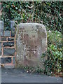
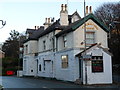
Milestone, Penmaenmawr
This old milestone is situated at the entrance to the small car park at the rear of the Mountain View Hotel, on what was the original A55 road before the village was by-passed and the route of the A55 was changed. There is an old 1GL Ordnance Survey benchmark on the milestone which was used during the Ordnance Survey's First Primary Levelling on the line between Warrington and Pembroke Docks, between September 1851 and July 1852. This was mark No. 249 along this levelling line and was 113.0960ft above the Liverpool datum.
Image: © Meirion
Taken: 17 Jan 2012
0.22 miles
10
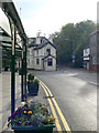
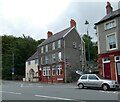
Mountain View Hotel, Penmaenmawr
On the junction of Bangor Road and Conwy Old Road.
Image: © Eirian Evans
Taken: 24 Apr 2009
0.22 miles