IMAGES TAKEN NEAR TO
Bryn Rhedyn, LLANFAIRFECHAN, LL33 0UP
Introduction
This page details the photographs taken nearby to Bryn Rhedyn, LL33 0UP by members of the Geograph project.
The Geograph project started in 2005 with the aim of publishing, organising and preserving representative images for every square kilometre of Great Britain, Ireland and the Isle of Man.

There are currently over 7.5m images from over14,400 individuals and you can help contribute to the project by visiting https://www.geograph.org.uk
Image Map (Loading...)


Getting Data...Please wait
Leaflet Map data © OpenStreetMap
Images are licensed for reuse under creativecommons.org/licenses/by-sa/2.0
Notes
- Clicking on the map will re-center to the selected point.
- The higher the marker number, the further away the image location is from the centre of the postcode.
Image Listing (57 Images Found)
Images are licensed for reuse under creativecommons.org/licenses/by-sa/2.0
Image
Details
Distance
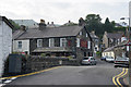
1
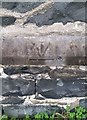
Ordnance Survey Cut Mark
This OS cut mark can be found on the wall of the Fire Station. It marks a point 57.790m above mean sea level.
Image: © Adrian Dust
Taken: 26 Oct 2018
0.05 miles
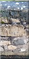
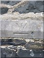
2
Benchmark on Llannerch Road, Llanfairfechan
For more details see: https://www.bench-marks.org.uk/bm101490
Image: © Meirion
Taken: 11 Mar 2019
0.05 miles
3
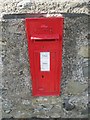
King George V post box, Llanfairfechan
LL33 231
Image: © Meirion
Taken: 6 Aug 2019
0.11 miles
4
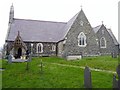
Ordnance Survey 1GL Bolt
This OS Bolt can be found on the SE face of Eglwys Y Santes Fair. It marks a point 56.789m above mean sea level.
Image: © Adrian Dust
Taken: 26 Oct 2018
0.13 miles
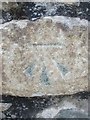
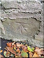
5
1GL benchmark & bolt on Eglwys y Santes Fair, Llanfairfechan
This inverted 1GL benchmark & bolt is located on the SE face of Eglwys y Santes Fair in Llanfairfechan. It was used during the Ordnance Survey's First Primary Levelling on the line between Warrington and Pembroke Docks, between September 1851 and July 1852. This mark was a branch levelling from mark No. 257 on the main levelling line and was 185.9510ft above the Liverpool datum.
Image: © Meirion
Taken: 1 Dec 2011
0.13 miles
7
Benchmark on Cae Ffynnon Road, Llanfairfechan
This benchmark is located on the NE side of Cae Ffynnon Road in Llanfairfechan. The mark is not shown in the current Ordnance Survey database but is shown on an 1901 map of the area as being 110.4ft above the Liverpool datum.
Image: © Meirion
Taken: 23 Sep 2010
0.14 miles
8
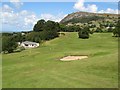
Golf course
The Llanfairfechan Golf Club has a well-regarded, nine-hole parkland course on an improbably steep site to the south-west of the town. The clubhouse is seen at the left of the image.
Image: © Jonathan Wilkins
Taken: 22 Aug 2014
0.14 miles
9
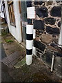
A black/white striped pole on Mill Road, Llanfairfechan
Image: © Meirion
Taken: 6 Sep 2019
0.15 miles