IMAGES TAKEN NEAR TO
Wig Crossing, LLANFAIRFECHAN, LL33 0LT
Introduction
This page details the photographs taken nearby to Wig Crossing, LL33 0LT by members of the Geograph project.
The Geograph project started in 2005 with the aim of publishing, organising and preserving representative images for every square kilometre of Great Britain, Ireland and the Isle of Man.

There are currently over 7.5m images from over14,400 individuals and you can help contribute to the project by visiting https://www.geograph.org.uk
Image Map (Loading...)


Getting Data...Please wait
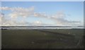
Leaflet Map data © OpenStreetMap
Images are licensed for reuse under creativecommons.org/licenses/by-sa/2.0
Notes
- Clicking on the map will re-center to the selected point.
- The higher the marker number, the further away the image location is from the centre of the postcode.
Image Listing (13 Images Found)
Images are licensed for reuse under creativecommons.org/licenses/by-sa/2.0
Image
Details
Distance
2
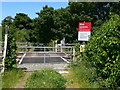
Wig crossing
Railway crossing without lights - there is a stile on either side for pedestrians to cross with care! The railway is the main London to Holyhead line.
Image: © Eirian Evans
Taken: 2 Jun 2009
0.03 miles
3
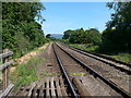
Wig crossing
Pedestrian crossing over the London to Holyhead railway line
Image: © Eirian Evans
Taken: 2 Jun 2009
0.05 miles
5
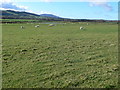
View inland from the Wales Coast Path
Snowdonia mountains in the distance.
Image: © Eirian Evans
Taken: 19 Mar 2012
0.14 miles
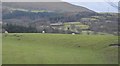
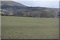
7
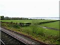
From a Chester-Holyhead train - Sheep pasture and woodland near Wig
Image: © Nigel Thompson
Taken: 2 May 2018
0.15 miles
8
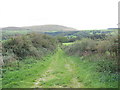
A Green Road linking the Shore with the A55
Image: © Eric Jones
Taken: 4 Oct 2006
0.19 miles
10
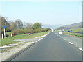
A55 North Wales Expressway near Wig Farm
Image: © Colin Pyle
Taken: 29 Mar 2019
0.22 miles