IMAGES TAKEN NEAR TO
Abergwyngregyn, LLANFAIRFECHAN, LL33 0LP
Introduction
This page details the photographs taken nearby to LL33 0LP by members of the Geograph project.
The Geograph project started in 2005 with the aim of publishing, organising and preserving representative images for every square kilometre of Great Britain, Ireland and the Isle of Man.

There are currently over 7.5m images from over14,400 individuals and you can help contribute to the project by visiting https://www.geograph.org.uk
Image Map
Images are licensed for reuse under creativecommons.org/licenses/by-sa/2.0
Notes
- Clicking on the map will re-center to the selected point.
- The higher the marker number, the further away the image location is from the centre of the postcode.
Image Listing (17 Images Found)
Images are licensed for reuse under creativecommons.org/licenses/by-sa/2.0
Image
Details
Distance
1
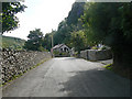
Road leaving Abergwyngregyn village
This is the road to the falls from the village, for those of us who walk from the bus stop!
Image: © John Rostron
Taken: 24 Aug 2009
0.09 miles
2
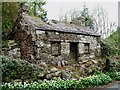
No One At Home
Derelict cottage in Abergwyngregyn.
Image: © Chris Andrews
Taken: 17 Apr 2017
0.16 miles
5
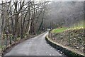
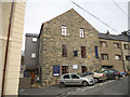
Group of buildings in Abergwyngregyn, Gwynedd
The largest building in this group is the old Mill, on the road up to Aber Falls
Image: © BrianPritchard
Taken: 2 Oct 2007
0.21 miles
6
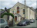
Former Chapel
Formal chapel at Abergwyngregyn, Gwynedd.
Image: © Keith Evans
Taken: 23 Apr 2017
0.22 miles
7
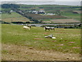
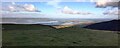
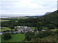
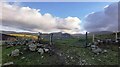
Ponies grazing on the hillside above the A55
Image: © Ian Greig
Taken: 18 Apr 2008
0.22 miles
9
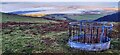
Feeding Trough with Lavan Mudflats Beyond
Image: © Anthony Parkes
Taken: 30 Jan 2023
0.23 miles