IMAGES TAKEN NEAR TO
LLANFAIRFECHAN, LL33 0HD
Introduction
This page details the photographs taken nearby to LL33 0HD by members of the Geograph project.
The Geograph project started in 2005 with the aim of publishing, organising and preserving representative images for every square kilometre of Great Britain, Ireland and the Isle of Man.

There are currently over 7.5m images from over14,400 individuals and you can help contribute to the project by visiting https://www.geograph.org.uk
Image Map (Loading...)


Getting Data...Please wait
Leaflet Map data © OpenStreetMap
Images are licensed for reuse under creativecommons.org/licenses/by-sa/2.0
Notes
- Clicking on the map will re-center to the selected point.
- The higher the marker number, the further away the image location is from the centre of the postcode.
Image Listing (6 Images Found)
Images are licensed for reuse under creativecommons.org/licenses/by-sa/2.0
Image
Details
Distance
1
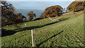
On coast path crossing field above Llanfairfechan
Image: © Colin Park
Taken: 23 Nov 2016
0.11 miles
2
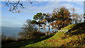
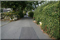
Autumn colours as seen from coast path E of Llanfairfechan
Image: © Colin Park
Taken: 23 Nov 2016
0.14 miles
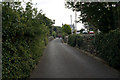
6
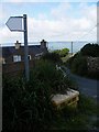
Mount Road Nant Y Pandy
The weathered sign marks the point where a field path goes off Mount Road. Anglesey is seen in the background.
Image: © Christopher Hall
Taken: 9 Aug 2014
0.25 miles