
IMAGES TAKEN NEAR TO
Glanyrafon Road, LLANFAIRFECHAN, LL33 0EY
Introduction
This page details the photographs taken nearby to Glanyrafon Road, LL33 0EY by members of the Geograph project.
The Geograph project started in 2005 with the aim of publishing, organising and preserving representative images for every square kilometre of Great Britain, Ireland and the Isle of Man.

There are currently over 7.5m images from over14,400 individuals and you can help contribute to the project by visiting https://www.geograph.org.uk
Image Map
Images are licensed for reuse under creativecommons.org/licenses/by-sa/2.0
Notes
- Clicking on the map will re-center to the selected point.
- The higher the marker number, the further away the image location is from the centre of the postcode.
Image Listing (20 Images Found)
Images are licensed for reuse under creativecommons.org/licenses/by-sa/2.0
Image
Details
Distance
1

Glan-yr-afon 2
The derelict farmhouse of Glan yr Afon, seen from the road to Blaenau. It is always saddening to see historic buildings like this in disrepair, but farms must be larger to be economic today.
Image: © Jonathan Wilkins
Taken: 16 May 2021
0.08 miles
2

Glan-yr-afon 1
Farm buildings at Glan yr Afon astride the road to Blaenau. Nowadays the farm is uninhabited but the farm buildings are still occupied, and the long, hilly road from Llanfairfechan has been augmented by Newry Drive ascending from Valley Road and Nant y Pandy. This track is in use as a permissive path to Dinas.
Image: © Jonathan Wilkins
Taken: 16 May 2021
0.09 miles
3

Looking down the valley
The streams here feed into the Afon Llanfairfechan.
Image: © David Medcalf
Taken: 17 Aug 2019
0.12 miles
4

Boulder wall with lambs
I was so impressed by the old field wall built with large, glacially-derived boulders, that at first I failed to spot the lambs climbing around on them! The abundance of these boulders within the catchment of the Afon Llanfairfechan is quite extraordinary.
Image: © Jonathan Wilkins
Taken: 16 May 2021
0.17 miles
5
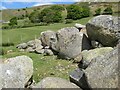
Glacial erratic boulders
Well-tended pastures at Blaen-llwyn have been cleared of large boulders, which have been dragged to the lowest part of the farm where there is boggy, unproductive ground. Some are very large, and all are extremely hard (according to the farmer); see the mauve belt-pack for scale. My self-portable scale objects (aka dogs) were not available at this point due to lamb and sheep sensitivities. There is interest in the fact that there are rounded, well-travelled boulders mingled with much more angular pieces of micro-diorite from the adjacent hill. Once again I am drawn to comment on the exceptional abundance of glacial erratic boulders in this catchment. Access to this private area was granted by the landowners.
Image: © Jonathan Wilkins
Taken: 18 May 2021
0.18 miles
6

Boulder wall
Glacially-derived boulders are particularly abundant in this area, which provided an abundant source of building material for walls dividing the improved fields. I was drawn to this strangely coppiced oak tree and the fabulous texture of the boulder wall.
Image: © Jonathan Wilkins
Taken: 16 May 2021
0.19 miles

9

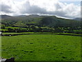
Green valley
Improved fields lie in the valley below bracken-infested mountain pastures. Angular rocks make the foundation of the workmen's path, which is still running above cliffs which deny a safe route downhill. In the distance can be seen Dinas with its westward-facing scree slopes. Dinas comprises a small offshoot from the main igneous intrusion which makes up Penmaen Mawr with its many quarry workings.
Image: © Jonathan Wilkins
Taken: 4 Aug 2022
0.21 miles
10

Blaen-llwyn
A view over the improved fields and moorland of Blaen-llwyn.
Image: © Jonathan Wilkins
Taken: 18 May 2021
0.21 miles