IMAGES TAKEN NEAR TO
Llanbedr-y-Cennin, CONWY, LL32 8UR
Introduction
This page details the photographs taken nearby to LL32 8UR by members of the Geograph project.
The Geograph project started in 2005 with the aim of publishing, organising and preserving representative images for every square kilometre of Great Britain, Ireland and the Isle of Man.

There are currently over 7.5m images from over14,400 individuals and you can help contribute to the project by visiting https://www.geograph.org.uk
Image Map
Images are licensed for reuse under creativecommons.org/licenses/by-sa/2.0
Notes
- Clicking on the map will re-center to the selected point.
- The higher the marker number, the further away the image location is from the centre of the postcode.
Image Listing (6 Images Found)
Images are licensed for reuse under creativecommons.org/licenses/by-sa/2.0
Image
Details
Distance
1
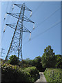
Electricity pylon
The transmission lines descending to cross the Conwy Valley dominate this area. Here the line crosses the minor road as it descends steeply near Tyddyn Wern. Pointing the camera upwards has given a dramatic and menacing lean to the pylon.
Image: © Jonathan Wilkins
Taken: 4 Jun 2012
0.15 miles
2
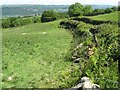
Road with hedges
Steep banks surmounted with hedges hide the road completely as it descends steeply into the valley. The pasture has run to thistles, and a derelict mowing machine rusts near to the gate. Electricity cables just clip the corner of the image.
Image: © Jonathan Wilkins
Taken: 4 Jun 2012
0.18 miles
3
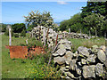
Wall with May blossom
I could not resist this composition of field wall, rusty corrugated-iron sheet, brambles and May blossom. I know that it was taken in June, but you must allow for the altitude of 250m and the exposed location.
Image: © Jonathan Wilkins
Taken: 4 Jun 2012
0.19 miles
4
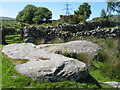
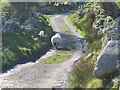
Erratic boulders
A pair of wonderful, glacial erratics that lie just inside the field wall, itself made with glacially derived material. These are not bedrock, and their rounded features tell of immense forces at work during transport within a glacier. Each of these has a long axis of approximately 5 metres, and must weigh tens of tons.
Image: © Jonathan Wilkins
Taken: 4 Jun 2012
0.20 miles
5
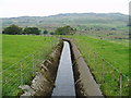
Leat
The leat transports water across open farmland. Picture taken at SH 74138 70571, where the leat crosses the farm track, looking north-west towards Tal y Fan.
Image: © Martyn B
Taken: 4 Oct 2005
0.21 miles
6
Near Tyddyn Bach
Sheep on the steep hill near Tyddyn Bach
Image: © Alan hodgson
Taken: 27 Apr 2005
0.22 miles