IMAGES TAKEN NEAR TO
Tyn-y-Groes, CONWY, LL32 8TH
Introduction
This page details the photographs taken nearby to LL32 8TH by members of the Geograph project.
The Geograph project started in 2005 with the aim of publishing, organising and preserving representative images for every square kilometre of Great Britain, Ireland and the Isle of Man.

There are currently over 7.5m images from over14,400 individuals and you can help contribute to the project by visiting https://www.geograph.org.uk
Image Map
Images are licensed for reuse under creativecommons.org/licenses/by-sa/2.0
Notes
- Clicking on the map will re-center to the selected point.
- The higher the marker number, the further away the image location is from the centre of the postcode.
Image Listing (6 Images Found)
Images are licensed for reuse under creativecommons.org/licenses/by-sa/2.0
Image
Details
Distance
1
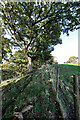
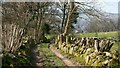
Fenceline above Ty'n-y-Groes
The public footpath from Ty'n-y-Groes towards Glyn Uchaf crosses a stile into a field and becomes very vague - the mapping on my GPS seemed to indicate that it came up here and then turned left to cross the stream further north than is actually the case (and as is shown on more modern maps online). Needless to say, a retreat and search soon revealed the correct route, but most of the sheep in the field seemed to find my venture very interesting and accompanied me up to this point. Since the path seemed little used, perhaps they expect no-one to venture here except those carrying handy bags of sheep nuts...
Image: © Andy Waddington
Taken: 12 Nov 2022
0.11 miles
2
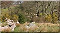
An Easter Walk in the Conwy Valley - 20
The photograph was taken from a public footpath connecting an unclassified road (left) between Ty’n-y-groes and Rowen with Pontwgan (right).
The immediate foreground was somewhat marshy and wet underfoot.
The dip following the line of gorse is a stream and beyond that there are sheep in the field.
To see the next photograph on this walk, click here Image
To see the previous photograph on the walk, click here Image
To go to the start of the walk, click here Image
Image: © Alan Walker
Taken: 8 Apr 2007
0.20 miles
3
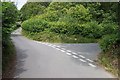
Road Junction near Clytiau-poethion
The road junction near Clytiau-poethion at SH 76581 71875.
Image: © Terry Hughes
Taken: 26 Jul 2006
0.20 miles
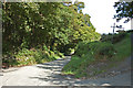
5
An Easter Walk in the Conwy Valley - 19
The photograph shows the end of a track carrying a public footpath westward from the B5106. This footpath is part of a walk that leads from the little church of St Mary, Caer Rhun to Ty’n-y-groes and back via Pontwgan.
Behind the viewpoint the track started on the northern outskirts of Ty’n-y-groes on the B5106 opposite it junction with Glan-y-wern http://www.multimap.com/map/browse.cgi?lat=53.2304&lon=-3.8372&scale=25000&icon=x .
Ahead the footpath enters a field and carries on westward and then northward toward Glyn Uchaf.
However, this walk doesn’t follow that route for, after some 50 metres or so, another path crosses the field southward to join an unclassified road connecting Ty’n-y-groes with Rowen http://www.multimap.com/map/browse.cgi?lat=53.2294&lon=-3.842&scale=25000&icon=x .
Follow the unclassified road westward for approximately 300metres and then join another public footpath http://www.multimap.com/map/browse.cgi?lat=53.229&lon=-3.8446&scale=25000&icon=x heading southward toward Pontwgan.
To see the next photograph on this walk, click here Image
To see the previous photograph on the walk, click here Image
To go to the start of the walk, click here Image
Image: © Alan Walker
Taken: 8 Apr 2007
0.24 miles
6
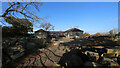
Building site above Ty'n-y-Groes
A public footpath from Ty'n-y-Groes starts as a track passing one house before ending at this point where building work is going on. The path continues into a field on the photographer's left.
Image: © Andy Waddington
Taken: 12 Nov 2022
0.24 miles