IMAGES TAKEN NEAR TO
Cadnant Park, CONWY, LL32 8PP
Introduction
This page details the photographs taken nearby to Cadnant Park, LL32 8PP by members of the Geograph project.
The Geograph project started in 2005 with the aim of publishing, organising and preserving representative images for every square kilometre of Great Britain, Ireland and the Isle of Man.

There are currently over 7.5m images from over14,400 individuals and you can help contribute to the project by visiting https://www.geograph.org.uk
Image Map
Images are licensed for reuse under creativecommons.org/licenses/by-sa/2.0
Notes
- Clicking on the map will re-center to the selected point.
- The higher the marker number, the further away the image location is from the centre of the postcode.
Image Listing (968 Images Found)
Images are licensed for reuse under creativecommons.org/licenses/by-sa/2.0
Image
Details
Distance
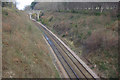
2
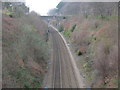
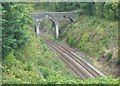
North Wales Coast Line
This stretch of the line is just after Conwy Railway Station. The next station is at Penmaenmawr.
Image: © G Laird
Taken: 17 Mar 2015
0.03 miles
3
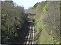
Railway to Holyhead as seen from the town walls
Image: © Row17
Taken: 15 Apr 2008
0.04 miles
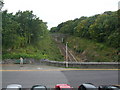
6
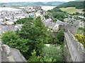
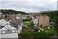
Conwy town walls and castle
The walls run to a vee on high ground uphill of the castle site, offering a perspective back over the old town.
Image: © Jeremy Bolwell
Taken: 14 Jul 2010
0.04 miles
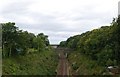
7
Railway to Bangor
A stretch of the Chester - Holyhead main line seen from Mount Pleasant.
Image: © Stephen McKay
Taken: 1 Apr 2013
0.05 miles