IMAGES TAKEN NEAR TO
Maes Baclaw, CONWY, LL32 8NJ
Introduction
This page details the photographs taken nearby to Maes Baclaw, LL32 8NJ by members of the Geograph project.
The Geograph project started in 2005 with the aim of publishing, organising and preserving representative images for every square kilometre of Great Britain, Ireland and the Isle of Man.

There are currently over 7.5m images from over14,400 individuals and you can help contribute to the project by visiting https://www.geograph.org.uk
Image Map
Images are licensed for reuse under creativecommons.org/licenses/by-sa/2.0
Notes
- Clicking on the map will re-center to the selected point.
- The higher the marker number, the further away the image location is from the centre of the postcode.
Image Listing (5 Images Found)
Images are licensed for reuse under creativecommons.org/licenses/by-sa/2.0
Image
Details
Distance
1
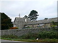
Baclaw
A farm on the western side of the Conwy valley.
Image: © Eirian Evans
Taken: 20 Nov 2007
0.02 miles
2
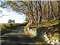
Coed Baclaw
The Autumn canopy is opening up in this young plantation of mostly oak trees, seen here from the road margin. The roadside wall is made of very characteristic erratic boulders harvested from the nearby fields.
Image: © Jonathan Wilkins
Taken: 14 Nov 2014
0.18 miles
3
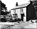
Cae Col farm
This cottage was rented from the Williams family (who lived in the nearby hall) by my grandparents James and Laura Lloyd, who lived there from 1954 to 1970. They sold eggs to people staying at the Gorse Hill caravan park. After they left, the place was modernised, abandoned in the late 1990s and eventually demolished. Several modern chalets cover the site now.
Image: © Philip Lloyd
Taken: Unknown
0.18 miles
4
View towards The Groes Inn
The Inn is slightly off centre right.
Image: © Richard Hoare
Taken: 19 Aug 2013
0.19 miles
5
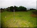
Gorse Hill & Iolyn Park
Gorse Hill or Iolyn Park, SH 77588 75228 131 metres. Possible subHuMP relocation.
Image: © Rude Health
Taken: 24 Nov 2012
0.21 miles