IMAGES TAKEN NEAR TO
Llanrwst Road, CONWY, LL32 8HZ
Introduction
This page details the photographs taken nearby to Llanrwst Road, LL32 8HZ by members of the Geograph project.
The Geograph project started in 2005 with the aim of publishing, organising and preserving representative images for every square kilometre of Great Britain, Ireland and the Isle of Man.

There are currently over 7.5m images from over14,400 individuals and you can help contribute to the project by visiting https://www.geograph.org.uk
Image Map
Images are licensed for reuse under creativecommons.org/licenses/by-sa/2.0
Notes
- Clicking on the map will re-center to the selected point.
- The higher the marker number, the further away the image location is from the centre of the postcode.
Image Listing (6 Images Found)
Images are licensed for reuse under creativecommons.org/licenses/by-sa/2.0
Image
Details
Distance
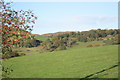
1
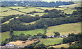
Gyffin Hillside
Hillside above Gyffin viewed from North (school just visible at bottom of picture).
Image: © Chris Shaw
Taken: Unknown
0.09 miles
2
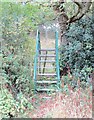
Camfa crand / A stylish stile
This stile seems to be unusually elaborate, given that it crosses a fairly insignificant fence.
Image: © Ceri Thomas
Taken: 17 Oct 2015
0.17 miles
6
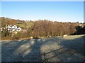
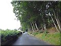
Frost and shadow
Shadows falling onto frosty pasture seem somehow to miss the sheep! A view across the Afon Gyffin towards Hendre.
Image: © Jonathan Wilkins
Taken: 15 Dec 2022
0.25 miles