IMAGES TAKEN NEAR TO
CONWY, LL32 8GA
Introduction
This page details the photographs taken nearby to LL32 8GA by members of the Geograph project.
The Geograph project started in 2005 with the aim of publishing, organising and preserving representative images for every square kilometre of Great Britain, Ireland and the Isle of Man.

There are currently over 7.5m images from over14,400 individuals and you can help contribute to the project by visiting https://www.geograph.org.uk
Image Map
Images are licensed for reuse under creativecommons.org/licenses/by-sa/2.0
Notes
- Clicking on the map will re-center to the selected point.
- The higher the marker number, the further away the image location is from the centre of the postcode.
Image Listing (57 Images Found)
Images are licensed for reuse under creativecommons.org/licenses/by-sa/2.0
Image
Details
Distance
1
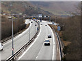
A55 passing Conwy Mountain
The A55, looking westwards from junction 17, as it passes Conwy Mountain.
Image: © David Dixon
Taken: 19 Feb 2010
0.06 miles
2
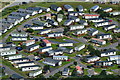
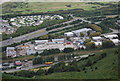
Looking down on Aberconwy Resort from Conwy Mountain
Image: © David Martin
Taken: 7 Aug 2016
0.09 miles
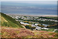
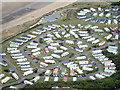
7
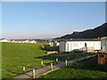
Aberconwy Park
When the new A55 expressway was built, the original caravan park was relocated. It is now much more up-market with mobile homes rather than caravans.
Image: © Jonathan Wilkins
Taken: 27 Sep 2008
0.12 miles
8
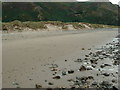
Wales Coast Path at Conwy Morfa
At this point the National Cycle Route 5 leaves the Wales Coast Path.
Image: © Ian S
Taken: 17 Sep 2014
0.12 miles
10
Industrial estate at the foot of Conwy Mountain
Image: © N Chadwick
Taken: 29 Aug 2009
0.13 miles