IMAGES TAKEN NEAR TO
Whinacres, CONWY, LL32 8ET
Introduction
This page details the photographs taken nearby to Whinacres, LL32 8ET by members of the Geograph project.
The Geograph project started in 2005 with the aim of publishing, organising and preserving representative images for every square kilometre of Great Britain, Ireland and the Isle of Man.

There are currently over 7.5m images from over14,400 individuals and you can help contribute to the project by visiting https://www.geograph.org.uk
Image Map
Images are licensed for reuse under creativecommons.org/licenses/by-sa/2.0
Notes
- Clicking on the map will re-center to the selected point.
- The higher the marker number, the further away the image location is from the centre of the postcode.
Image Listing (38 Images Found)
Images are licensed for reuse under creativecommons.org/licenses/by-sa/2.0
Image
Details
Distance
1
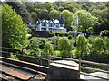
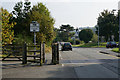
From a Chester-Holyhead train - passing the Park Hall Hotel
Image: © Nigel Thompson
Taken: 2 May 2018
0.13 miles
2
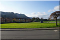
Green space by Gerddi'r Morfa
Housing in Conwy with Conwy Mountain providing an impressive backdrop.
Image: © Bill Boaden
Taken: 18 Feb 2017
0.13 miles
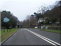
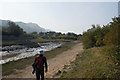
6
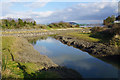
Muddy creek in Conwy
A creek off the Conwy River as seen from Morfa Drive.
Image: © Bill Boaden
Taken: 18 Feb 2017
0.16 miles
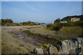
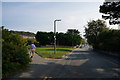
10
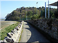
Bridleway beside Ysgol Aberconwy
Looking towards Bodlondeb Woods
Image: © Phil Champion
Taken: 19 Apr 2009
0.18 miles