IMAGES TAKEN NEAR TO
Ronald Avenue, LLANDUDNO JUNCTION, LL31 9UQ
Introduction
This page details the photographs taken nearby to Ronald Avenue, LL31 9UQ by members of the Geograph project.
The Geograph project started in 2005 with the aim of publishing, organising and preserving representative images for every square kilometre of Great Britain, Ireland and the Isle of Man.

There are currently over 7.5m images from over14,400 individuals and you can help contribute to the project by visiting https://www.geograph.org.uk
Image Map
Images are licensed for reuse under creativecommons.org/licenses/by-sa/2.0
Notes
- Clicking on the map will re-center to the selected point.
- The higher the marker number, the further away the image location is from the centre of the postcode.
Image Listing (13 Images Found)
Images are licensed for reuse under creativecommons.org/licenses/by-sa/2.0
Image
Details
Distance
1
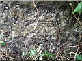
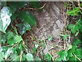
Ordnance Survey Cut Mark
This OS cut mark can be found on the wall SW side of Narrow Lane. It marks a point 29.926m above mean sea level.
Image: © Adrian Dust
Taken: 12 Sep 2023
0.10 miles
2
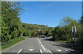
Roundabout ahead
Taken from the minor road from Llandudno Junction and the roundabout is on the A470.
Image: © Steve Fareham
Taken: 2 May 2011
0.13 miles
3
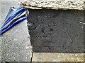
Ordnance Survey Cut Mark
This OS cut mark can be found on No37 Ronald Avenue. It marks a point 20.326m above mean sea level.
Image: © Adrian Dust
Taken: 12 Sep 2023
0.14 miles
4
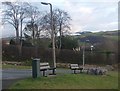
Meinciau / Benches
These benches provide fine views over the Conwy estuary.
Image: © Ceri Thomas
Taken: 1 Jan 2010
0.18 miles
5
Ordnance Survey Cut Mark
This OS cut mark can be found on the gatepost of Cae Ffynnon. It marks a point 24.510m above mean sea level.
Image: © Adrian Dust
Taken: 12 Sep 2023
0.19 miles
6
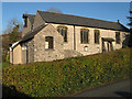
St.Michael & All Angels
A neat and restrained building in a surprising location at the end of Glyn-y-marl Road. The twin-nave design appears to be short of a tower at its west end, making-do instead with a cantilevered roof over a small belfry and a fine weather vane with an astrolabe and a sheep motif for the pointer.
Image: © Jonathan Wilkins
Taken: 15 Jan 2012
0.21 miles
7
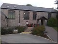
St Michael and All Angels Church, Llandudno Junction
'Wiggle and Giggle' takes place there on a Friday. A music / dance session for under 4's.
Image: © Richard Hoare
Taken: 21 Oct 2016
0.22 miles
9
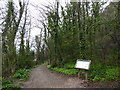
Footpath at Marl Woods
The wood once formed part of the grounds of Marle Hall and is now maintained by the Woodland Trust.
Image: © Eirian Evans
Taken: 10 Apr 2018
0.23 miles
10
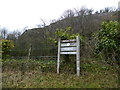
Marl Hall Woods
Woodland Trust notice by the car park to the woods. Beyond is a limestone cliff, also part of the woodland and affording fine views from the top.
Image: © Eirian Evans
Taken: 10 Apr 2018
0.24 miles