IMAGES TAKEN NEAR TO
Albert Drive, CONWY, LL31 9SR
Introduction
This page details the photographs taken nearby to Albert Drive, LL31 9SR by members of the Geograph project.
The Geograph project started in 2005 with the aim of publishing, organising and preserving representative images for every square kilometre of Great Britain, Ireland and the Isle of Man.

There are currently over 7.5m images from over14,400 individuals and you can help contribute to the project by visiting https://www.geograph.org.uk
Image Map
Images are licensed for reuse under creativecommons.org/licenses/by-sa/2.0
Notes
- Clicking on the map will re-center to the selected point.
- The higher the marker number, the further away the image location is from the centre of the postcode.
Image Listing (188 Images Found)
Images are licensed for reuse under creativecommons.org/licenses/by-sa/2.0
Image
Details
Distance
2
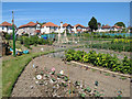
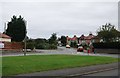
Allotment gardens
Looking over these beautiful allotments towards St George's Drive. The cabbages are in and the bird-scarers deployed, while the currants and raspberries are doing well now the sun is shining.
Image: © Jonathan Wilkins
Taken: 6 Jun 2013
0.04 miles
4
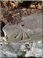
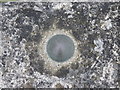
Rivet benchmark on Albert Drive, Llandudno Junction
More information at: http://www.bench-marks.org.uk/bm52428
Image: © Meirion
Taken: 31 Oct 2013
0.05 miles
5

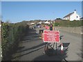
Road works, Glan y Mor Road
Road works to make a new traffic arrangement at the junction of Glan-y-Mor Road and New Road - a location always known to locals as Brierley's Corner. This work is associated with the new supermarket development - see Image
Image: © Jonathan Wilkins
Taken: 6 Feb 2020
0.05 miles
7
OSBM bolt benchmark on The Anchorage boundary wall, Llandudno Junction
This Ordnance Survey benchmark bolt is located on the low boundary wall of the Anchorage on the S side of the A546 in Llandudno Junction & it is shown in the current Ordnance Survey database at a height of 5.3797m above the Newlyn datum.
Image: © Meirion
Taken: 19 Jul 2011
0.06 miles
8
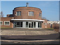
Adeilad crwn / A circular building
The circular building is an accountant's office. The grey roof in the background forms part of the recycling depot for Crest Co-operative.
Image: © Ceri Thomas
Taken: 6 Feb 2010
0.08 miles
10
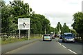
Temporary traffic lights
Three way traffic control approaching the roadworks at the junction of Glan-y-Mor Road and New Road. The work is associated with the new supermarket development - see Image
Image: © Jonathan Wilkins
Taken: 6 Feb 2020
0.09 miles