IMAGES TAKEN NEAR TO
Tan Y Bryn, LLANDUDNO JUNCTION, LL31 9PA
Introduction
This page details the photographs taken nearby to Tan Y Bryn, LL31 9PA by members of the Geograph project.
The Geograph project started in 2005 with the aim of publishing, organising and preserving representative images for every square kilometre of Great Britain, Ireland and the Isle of Man.

There are currently over 7.5m images from over14,400 individuals and you can help contribute to the project by visiting https://www.geograph.org.uk
Image Map
Images are licensed for reuse under creativecommons.org/licenses/by-sa/2.0
Notes
- Clicking on the map will re-center to the selected point.
- The higher the marker number, the further away the image location is from the centre of the postcode.
Image Listing (129 Images Found)
Images are licensed for reuse under creativecommons.org/licenses/by-sa/2.0
Image
Details
Distance
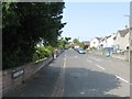
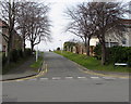
2
Playing field, Llandudno Junction
Surrounded by housing on 3 sides - Victoria Drive, Pant Gwyn and Tan y Bryn, this is a green oasis.
Image: © Eirian Evans
Taken: 28 Jan 2012
0.07 miles
3
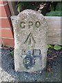
GPO cable marker on Victoria Drive, Llandudno Junction
Image: © Meirion
Taken: 11 Mar 2020
0.08 miles
4
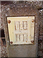
Hydrant marker on Victoria Drive, Llandudno Junction
Image: © Meirion
Taken: 11 Mar 2020
0.08 miles
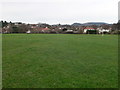
5

Open space and recreation ground, Llandudno Junction
Viewed from this http://www.geograph.org.uk/photo/4850410 gate. A football goalpost is on the right.
Image: © Jaggery
Taken: 27 Feb 2016
0.10 miles
6
Derwen Deg Day Centre, Llandudno Junction
Located in the cul-de-sac named Plas Tre Marl, accessed from Broad Street.
Image: © Jaggery
Taken: 27 Feb 2016
0.10 miles
7
Bryn Eglwys, Llandudno Junction
Viewed across Victoria Drive from the corner of Broad Street.
Bryn Eglwys leads to the Most Holy Family Church. http://www.geograph.org.uk/photo/4850318
Image: © Jaggery
Taken: 27 Feb 2016
0.10 miles
8

Dim cerbydau/No vehicles notice, Llandudno Junction
Facing the street named Bryn Eglwys, the bilingual (Welsh/English) notice is on the gate to a recreation ground.
Image: © Jaggery
Taken: 27 Feb 2016
0.10 miles
9

Dim Baeddu/No Fouling notice, Llandudno Junction
The bilingual (Welsh/English) notice faces the northern end of Bryn Eglwys http://www.geograph.org.uk/photo/4850356
at the entrance to a recreation ground. http://www.geograph.org.uk/photo/4850416 No dogs allowed on the marked sports pitch.
Image: © Jaggery
Taken: 27 Feb 2016
0.10 miles
10

Private car park for church parishioners only, Llandudno Junction
The notice faces the street named Bryn Eglwys at the entrance to the car park on the west side of Most Holy Family Church. http://www.geograph.org.uk/photo/4850318
Image: © Jaggery
Taken: 27 Feb 2016
0.11 miles