IMAGES TAKEN NEAR TO
Marl Gardens, CONWY, LL31 9LZ
Introduction
This page details the photographs taken nearby to Marl Gardens, LL31 9LZ by members of the Geograph project.
The Geograph project started in 2005 with the aim of publishing, organising and preserving representative images for every square kilometre of Great Britain, Ireland and the Isle of Man.

There are currently over 7.5m images from over14,400 individuals and you can help contribute to the project by visiting https://www.geograph.org.uk
Image Map
Images are licensed for reuse under creativecommons.org/licenses/by-sa/2.0
Notes
- Clicking on the map will re-center to the selected point.
- The higher the marker number, the further away the image location is from the centre of the postcode.
Image Listing (30 Images Found)
Images are licensed for reuse under creativecommons.org/licenses/by-sa/2.0
Image
Details
Distance
1
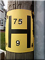
Hydrant sign on telephone pole, Llandudno Junction
Image: © Meirion
Taken: 11 Mar 2020
0.06 miles
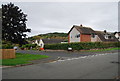
2
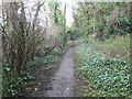
Footpath up the Vardre
Eventually this path leads to the site of Deganwy Castle
Image: © Eirian Evans
Taken: 28 Jan 2012
0.09 miles
3
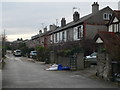
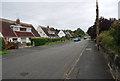
Shamrock Terrace, Tywyn
Built in the early 1900's, this terrace is just off Marl Road.
Image: © Eirian Evans
Taken: 28 Jan 2012
0.09 miles
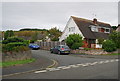
4
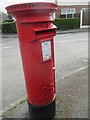
Elizabeth II pillar box on Victoria Drive, Llandudno Junction
LL31 82D
Image: © Meirion
Taken: 11 Mar 2020
0.11 miles
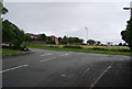
6
Dol Hudol
Cul-de-sac off Victoria Drive.
Image: © Gerald England
Taken: 10 Jul 2014
0.15 miles