IMAGES TAKEN NEAR TO
Dol Goed, LLANDUDNO JUNCTION, LL31 9LH
Introduction
This page details the photographs taken nearby to Dol Goed, LL31 9LH by members of the Geograph project.
The Geograph project started in 2005 with the aim of publishing, organising and preserving representative images for every square kilometre of Great Britain, Ireland and the Isle of Man.

There are currently over 7.5m images from over14,400 individuals and you can help contribute to the project by visiting https://www.geograph.org.uk
Image Map
Images are licensed for reuse under creativecommons.org/licenses/by-sa/2.0
Notes
- Clicking on the map will re-center to the selected point.
- The higher the marker number, the further away the image location is from the centre of the postcode.
Image Listing (20 Images Found)
Images are licensed for reuse under creativecommons.org/licenses/by-sa/2.0
Image
Details
Distance
2
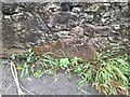
Ordnance Survey Cut Mark
This OS cut mark can be found on the wall SW side of Marl Lane. It marks a point 24.259m above mean sea level.
Image: © Adrian Dust
Taken: 12 Sep 2023
0.11 miles
3
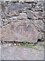
Benchmark on Marl Lane, Esgyryn
This benchmark is located on the SW side of Marl Lane in Esgyryn & it is shown in the current Ordnance Survey database at a height of 24.2585m above the Newlyn datum.
Image: © Meirion
Taken: 9 Jun 2011
0.11 miles
4
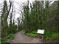
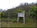
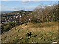
Footpath at Marl Woods
The wood once formed part of the grounds of Marle Hall and is now maintained by the Woodland Trust.
Image: © Eirian Evans
Taken: 10 Apr 2018
0.11 miles
5
Marl Hall Woods
Woodland Trust notice by the car park to the woods. Beyond is a limestone cliff, also part of the woodland and affording fine views from the top.
Image: © Eirian Evans
Taken: 10 Apr 2018
0.13 miles
8
Clogwyn yng Nghoed Marl / Cliff at Coed Marl
Image: © Ceri Thomas
Taken: 1 Jan 2010
0.16 miles
10
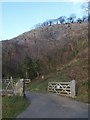
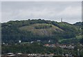
Marl Hall woods 2
Open ground above Marl Lane at the edge of Marl Hall woods. Chill winds have already stripped some of the trees and created a more open habitat - a real treat for my assistants. In the distance are the hills of the Vardre in Deganwy, which are our customary haunt.
Image: © Jonathan Wilkins
Taken: 3 Nov 2019
0.17 miles