IMAGES TAKEN NEAR TO
Penrhos Drive, LLANDUDNO, LL30 3LP
Introduction
This page details the photographs taken nearby to Penrhos Drive, LL30 3LP by members of the Geograph project.
The Geograph project started in 2005 with the aim of publishing, organising and preserving representative images for every square kilometre of Great Britain, Ireland and the Isle of Man.

There are currently over 7.5m images from over14,400 individuals and you can help contribute to the project by visiting https://www.geograph.org.uk
Image Map
Images are licensed for reuse under creativecommons.org/licenses/by-sa/2.0
Notes
- Clicking on the map will re-center to the selected point.
- The higher the marker number, the further away the image location is from the centre of the postcode.
Image Listing (49 Images Found)
Images are licensed for reuse under creativecommons.org/licenses/by-sa/2.0
Image
Details
Distance
1
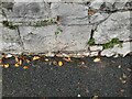
Ordnance Survey Cut Mark
This OS cut mark can be found on the wall of No66 Penrhyn-isaf Road. It marks a point 12.933m above mean sea level.
Image: © Adrian Dust
Taken: 12 Sep 2023
0.02 miles
2
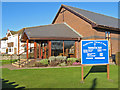
Presbyterian Church 1
The quiet and refined architecture of the church fits well with its aims, and is a real contrast with the seaside-suburbia that surround it. The history of the building is given in the companion image.
Image: © Jonathan Wilkins
Taken: 28 Jan 2011
0.10 miles
3
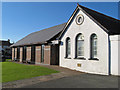
Presbyterian Church 2
Viewed from the eastern end, the building is clearly in two parts, and the white-painted building carries the date of 1905. Meetings were held originally in a private dwelling house at Morfa Cottages, until in 1905 the small chapel was built in Maesgwyn Road. This quickly became too small and in 1926 the modern building was completed, at which time the original building became the schoolroom. The distinctive white and black timber church was only ever intended to be temporary, but it was not until 1999 that it was refurbished to become the brick structure that is seen today.
http://www.penrhynbaypresbyterian.org.uk/
Image: © Jonathan Wilkins
Taken: 28 Jan 2011
0.10 miles
4
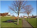
Penrhyn Bay park
Green, recreational space at the rear of the shops and library.
Image: © Jonathan Wilkins
Taken: 28 Jan 2011
0.11 miles
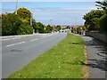
6
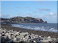
Bae Penrhyn
Penrhyn Bay on a clear December day looking towards the Little Orme
Image: © Dot Potter
Taken: 27 Dec 2005
0.12 miles
7
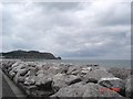
Bae Penrhyn
Looking across the manmade sea defences towards the Little Orme from Penrhyn Bay.
Image: © Dot Potter
Taken: 13 Aug 2005
0.12 miles
8
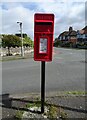
Elizabeth II postbox on Beach Drive, Penrhyn Bay
Postbox No. LL30 43.
See Image] for context.
Image: © JThomas
Taken: 15 Apr 2024
0.13 miles
10
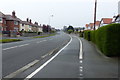
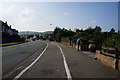
Glan-y-mor Road
Glan-y-mor Road in Penrhyn Bay.
Image: © Philip Halling
Taken: 26 May 2021
0.14 miles