
IMAGES TAKEN NEAR TO
Pant Y Ffridd, LLANDUDNO, LL30 2JR
Introduction
This page details the photographs taken nearby to Pant Y Ffridd, LL30 2JR by members of the Geograph project.
The Geograph project started in 2005 with the aim of publishing, organising and preserving representative images for every square kilometre of Great Britain, Ireland and the Isle of Man.

There are currently over 7.5m images from over14,400 individuals and you can help contribute to the project by visiting https://www.geograph.org.uk
Image Map
Images are licensed for reuse under creativecommons.org/licenses/by-sa/2.0
Notes
- Clicking on the map will re-center to the selected point.
- The higher the marker number, the further away the image location is from the centre of the postcode.
Image Listing (87 Images Found)
Images are licensed for reuse under creativecommons.org/licenses/by-sa/2.0
Image
Details
Distance
1
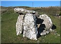
Siambr Gladdu/Burial Chamber
This is the best surviving monument to the Stone Age on The Great Orme. Originally it would probably have been covered with an earth mound. On the skyline, immediately above the chamber, is one of the supports for the Llandudno Cable Car system.
Image: © John S Turner
Taken: 5 Feb 2004
0.11 miles
2
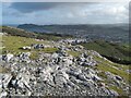
Limestone pavement
A fine, but localised development of limestone pavement on a rock platform above Pen-y-ffridd.
Image: © Jonathan Wilkins
Taken: 25 Feb 2021
0.11 miles
4
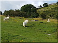
Kashmir goats at Maes-y-Facrell National Nature Reserve
The herd of Kashmir Goats has roamed the Orme since the 19th century and are descended from goats that were presented by the Shah of Persia to Queen Victoria in 1837. Numbers are controlled by artificial contraception to reduce competition for resources and to reduce them getting into gardens and properties in Llandudno.
Maes-y-Facrell National Nature Reserve is managed by Natural Resources Wales for its unique limestone flora such as the Great Orme Berry, Spiked Speedwell and Dark-Red Helleborine.
Image: © Colin Cheesman
Taken: 15 Aug 2019
0.12 miles
5
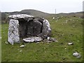
Llety'r Filiast Burial Chamber
Neolithic chambered round cairn.
Image: © Chris Andrews
Taken: 11 Feb 2015
0.14 miles
6
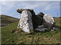
Lletty'r Filiast, Burial Chamber
This type of monument is a portal dolmen and consists of a small stone chamber originally covered by an earth mound. It is from the later Stone Age of about 6,800 years ago called the Neolithic period.
See http://www.greatorme.org.uk/canolfan.html
Image: © BrianPritchard
Taken: 1 Apr 2008
0.14 miles
7
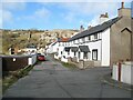
Anglesea Road
A very neat terrace of houses nestling on a ledge approximately half way up the Great Orme. Despite the protestations of modern road maps, the spelling of Anglesea on the old cast-iron street sign is absolutely specific.
Image: © Jonathan Wilkins
Taken: 25 Feb 2021
0.14 miles
8
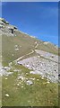
Footpath on Great Orme
One of the many footpaths that criss-cross the Great Orme.
Image: © Helen
Taken: 15 May 2016
0.15 miles
9
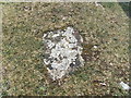
Ordnance Survey block - Maes-y-facrell, Llandudno
This small rivet embedded in concrete is a Ordnance Survey block style trigpoint.
The block is located on Maes-y-facrell which is part of the Great Orme Country Park. The block is located in front of a wooden waymark post and can therefore be easily located.
Although the coordinates for this block are recorded in the OS database no height information is given. My GPS gave a height of 190m.
Some excellent views of Llandudno & Conwy Bay from here.
See also: Image
Image: © Meirion
Taken: 4 May 2011
0.15 miles
10
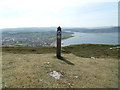
Ordnance Survey block & Waymark post - Maes-y-facrell, Llandudno
An Ordnance survey block style trigpoint can be seen close to the base of the wooden waymark post. See also: Image
Image: © Meirion
Taken: 4 May 2011
0.15 miles