IMAGES TAKEN NEAR TO
Abbey Road, LLANDUDNO, LL30 2EH
Introduction
This page details the photographs taken nearby to Abbey Road, LL30 2EH by members of the Geograph project.
The Geograph project started in 2005 with the aim of publishing, organising and preserving representative images for every square kilometre of Great Britain, Ireland and the Isle of Man.

There are currently over 7.5m images from over14,400 individuals and you can help contribute to the project by visiting https://www.geograph.org.uk
Image Map (Loading...)


Getting Data...Please wait
Leaflet Map data © OpenStreetMap
Images are licensed for reuse under creativecommons.org/licenses/by-sa/2.0
Notes
- Clicking on the map will re-center to the selected point.
- The higher the marker number, the further away the image location is from the centre of the postcode.
Image Listing (190 Images Found)
Images are licensed for reuse under creativecommons.org/licenses/by-sa/2.0
Image
Details
Distance
1
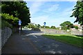
One way street ahead
Looking towards Church Walks in Llandudno.
Image: © DS Pugh
Taken: 20 Jun 2024
0.03 miles
2
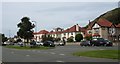
Villas on the north side of Gloddaeth Avenue
Image: © Eric Jones
Taken: 15 Aug 2008
0.03 miles
3
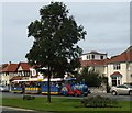
Land Train in Gloddaeth Avenue
This train links the beaches on the west and east side of the town.
http://llandudnoboattrips.co.uk/landtrain.aspx
Image: © Eric Jones
Taken: 15 Aug 2008
0.03 miles
4
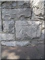
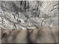
Benchmark on the boundary wall of Plas Gogarth on Church Walks, Llandudno
This benchmark is located on the boundary wall of Plas Gogarth on the NW side of Church Walks in Llandudno & it is shown in the current Ordnance Survey database at a height of 7.4852m above the Newlyn datum.
Image: © Meirion
Taken: 4 May 2011
0.04 miles
5
Ordnance Survey Cut Mark
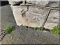
This OS cut mark can be found on the wall NW side of Church Walks. It marks a point 7.485m above mean sea level.
Image: © Adrian Dust
Taken: 27 Mar 2023
0.04 miles
6
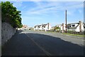
Houses along Abbey Road
The northern most residential street on the west side of Llandudno.
Image: © DS Pugh
Taken: 20 Jun 2024
0.04 miles
7
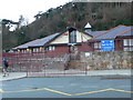
Ysgol San Sior, Llandudno
This school opened in 1993 to replace the old National School on Church Walks.
Image: © Eirian Evans
Taken: 6 Jan 2008
0.04 miles
8
Benchmark on Gloddaeth Avenue, Llandudno
This benchmark is located on the NW side of Gloddaeth Avenue in Llandudno & it is shown in the current Ordnance Survey database at a height of 5.7692m above the Newlyn datum.
Image: © Meirion
Taken: 11 Oct 2010
0.05 miles
9
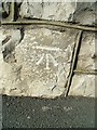
Ordnance Survey Cut Mark
This OS cut mark can be found on the wall NW side of Gloddaeth Avenue. It marks a point 5.769m above mean sea level.
Image: © Adrian Dust
Taken: 27 Mar 2023
0.06 miles
10
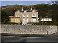
Plas Gogarth, Llandudno
Former care home, now for sale.
Image: © Eirian Evans
Taken: 28 Jan 2012
0.06 miles