IMAGES TAKEN NEAR TO
Alexandra Road, LLANDUDNO, LL30 2DQ
Introduction
This page details the photographs taken nearby to Alexandra Road, LL30 2DQ by members of the Geograph project.
The Geograph project started in 2005 with the aim of publishing, organising and preserving representative images for every square kilometre of Great Britain, Ireland and the Isle of Man.

There are currently over 7.5m images from over14,400 individuals and you can help contribute to the project by visiting https://www.geograph.org.uk
Image Map
Images are licensed for reuse under creativecommons.org/licenses/by-sa/2.0
Notes
- Clicking on the map will re-center to the selected point.
- The higher the marker number, the further away the image location is from the centre of the postcode.
Image Listing (32 Images Found)
Images are licensed for reuse under creativecommons.org/licenses/by-sa/2.0
Image
Details
Distance
1
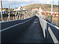
Temporary footbridge
The closure for reconstruction of the road bridge across the railway would mean an unacceptable diversion for people on foot to reach the schools and hospital. This temporary structure has been erected to serve during the building works. Ironically this is the exact alignment of the old level crossing which was replaced by the bridge in 1928.
Image: © Jonathan Wilkins
Taken: 16 Nov 2009
0.06 miles
3
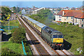
Railway at Llandudno
Train departing Llandudno.
Image: © Wayland Smith
Taken: 4 May 2019
0.07 miles
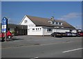
5
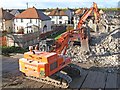
Orange machinery
Machinery at work clearing the remains of the Maesdu Bridge Image during an engineering occupation of the railway. The nearer machine is equipped with a hydraulic shear which can crush the steel-reinforced concrete and cut through the steelwork. The other is excavating the crushed rubble ready for removal from site.
Image: © Jonathan Wilkins
Taken: 16 Nov 2009
0.09 miles
7

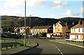
Railway north from Bryniau Road
The twin track branch line between Llandudno Junction and the town itself.
Image: © Stephen Craven
Taken: 20 Jun 2024
0.09 miles
8
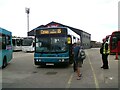
Changing buses
We were travelling on a #12 service to Conway. The driver diverted from the route and pulled into the Arriva bus garage. There we were asked to await the arrival of bus travelling in the opposite direction. When it arrived we were asked to transfer to the other bus for the remainder of the journey. The explanation given was that there was a driver changeover and the new driver was too tall to fit the cab of one of the buses.
Image: © Gerald England
Taken: 26 Jun 2021
0.10 miles
9
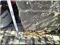
Ordnance Survey Cut Mark
This OS cut mark can be found on Railway Cottage. It marks a point 4.729m above mean sea level.
Image: © Adrian Dust
Taken: 27 Mar 2023
0.11 miles