IMAGES TAKEN NEAR TO
Balfour Road, LLANDUDNO, LL30 1TT
Introduction
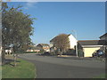
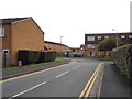
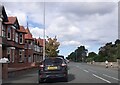
This page details the photographs taken nearby to Balfour Road, LL30 1TT by members of the Geograph project.
The Geograph project started in 2005 with the aim of publishing, organising and preserving representative images for every square kilometre of Great Britain, Ireland and the Isle of Man.

There are currently over 7.5m images from over14,400 individuals and you can help contribute to the project by visiting https://www.geograph.org.uk
Image Map
Images are licensed for reuse under creativecommons.org/licenses/by-sa/2.0
Notes
- Clicking on the map will re-center to the selected point.
- The higher the marker number, the further away the image location is from the centre of the postcode.
Image Listing (45 Images Found)
Images are licensed for reuse under creativecommons.org/licenses/by-sa/2.0
Image
Details
Distance
2
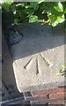
Ordnance Survey Pivot
This OS pivot can be found on the park wall east side of Queens Road. It marks a point 6.123m above mean sea level.
Image: © Adrian Dust
Taken: 14 Sep 2019
0.06 miles
3
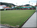
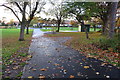
Craig y Don Bowling Club - Clarence Road
Image: © Betty Longbottom
Taken: 20 Jul 2012
0.08 miles
8
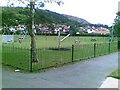
Craig y don recreation ground south-eastern entrance
Image: © Philip Jeffrey
Taken: 6 Nov 2015
0.14 miles