IMAGES TAKEN NEAR TO
Elwy Gardens, LLANDUDNO, LL30 1NJ
Introduction
This page details the photographs taken nearby to Elwy Gardens, LL30 1NJ by members of the Geograph project.
The Geograph project started in 2005 with the aim of publishing, organising and preserving representative images for every square kilometre of Great Britain, Ireland and the Isle of Man.

There are currently over 7.5m images from over14,400 individuals and you can help contribute to the project by visiting https://www.geograph.org.uk
Image Map
Images are licensed for reuse under creativecommons.org/licenses/by-sa/2.0
Notes
- Clicking on the map will re-center to the selected point.
- The higher the marker number, the further away the image location is from the centre of the postcode.
Image Listing (25 Images Found)
Images are licensed for reuse under creativecommons.org/licenses/by-sa/2.0
Image
Details
Distance
2
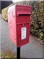
Elizabeth II post box on Maenan Road, Llandudno
LL30 70D
Image: © Meirion
Taken: 11 Mar 2020
0.04 miles
4
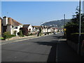
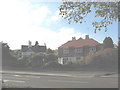
Conway Road
This busy dual carriage road leading into the centre of Llandudno is a section of the A470
Image: © Eric Jones
Taken: 20 Oct 2007
0.06 miles
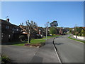
5
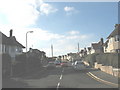
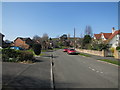
Large detached houses at the southern end of Queens Road
Image: © Eric Jones
Taken: 20 Oct 2007
0.11 miles
7
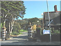
The entrance to the private North Wales Medical Centre
Image: © Eric Jones
Taken: 20 Oct 2007
0.15 miles
8
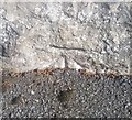
Ordnance Survey Cut Mark
This OS cut mark can be found on the wall east side of Queens Road. It marks a point 11.456m above mean sea level.
Image: © Adrian Dust
Taken: 14 Sep 2019
0.15 miles
10
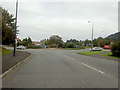
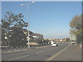
Roundabout on the outskirts of Llandudno
On the A470 just north of Bodysgallen hotel.
Image: © Steve Fareham
Taken: 10 Oct 2007
0.15 miles