IMAGES TAKEN NEAR TO
LL30 1FD
Introduction
This page details the photographs taken nearby to LL30 1FD by members of the Geograph project.
The Geograph project started in 2005 with the aim of publishing, organising and preserving representative images for every square kilometre of Great Britain, Ireland and the Isle of Man.

There are currently over 7.5m images from over14,400 individuals and you can help contribute to the project by visiting https://www.geograph.org.uk
Image Map
Images are licensed for reuse under creativecommons.org/licenses/by-sa/2.0
Notes
- Clicking on the map will re-center to the selected point.
- The higher the marker number, the further away the image location is from the centre of the postcode.
Image Listing (185 Images Found)
Images are licensed for reuse under creativecommons.org/licenses/by-sa/2.0
Image
Details
Distance
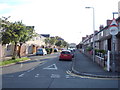
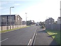
3
Cwm Road
A residential road leading away from the town centre. Ahead are some the buildings of John Bright Secondary School, and the higher ground of Bryniau is behind.
Image: © Bill Boaden
Taken: 17 Feb 2017
0.06 miles
7
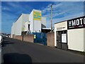
Bathers Self Storage, Builder Street, Llandudno
Image: © Stephen Craven
Taken: 20 Jun 2024
0.10 miles
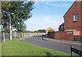
8
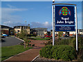
Ysgol John Bright
Fantastic new school campus, Ysgol John Bright is an 11-18, mixed, community school in Llandudno, Conwy. According to their website there are 1186 pupils on its roll.
Image: © Steve Fareham
Taken: 9 Oct 2007
0.11 miles
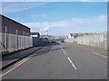
9
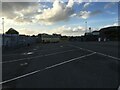
Bus yard, Builder Street West, Llandudno
Image: © Steven Brown
Taken: 28 Oct 2022
0.11 miles