IMAGES TAKEN NEAR TO
Roslyn Gardens, LLANDUDNO, LL30 1BS
Introduction
This page details the photographs taken nearby to Roslyn Gardens, LL30 1BS by members of the Geograph project.
The Geograph project started in 2005 with the aim of publishing, organising and preserving representative images for every square kilometre of Great Britain, Ireland and the Isle of Man.

There are currently over 7.5m images from over14,400 individuals and you can help contribute to the project by visiting https://www.geograph.org.uk
Image Map
Images are licensed for reuse under creativecommons.org/licenses/by-sa/2.0
Notes
- Clicking on the map will re-center to the selected point.
- The higher the marker number, the further away the image location is from the centre of the postcode.
Image Listing (119 Images Found)
Images are licensed for reuse under creativecommons.org/licenses/by-sa/2.0
Image
Details
Distance
1
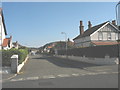
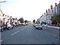
Craig-y-Don
Nant y Gamar Road - looking NW towards Llandudno promenade.
Image: © Chris Shaw
Taken: 11 Feb 2006
0.03 miles
2
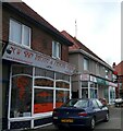
New Skin Tattoo & Piercing Studio
Next door is Craig y Don Post Office.
Image: © Gerald England
Taken: 4 Jul 2008
0.08 miles
3
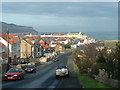
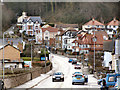
Nant y Gamar Road
Nant y Gamar Road heading to Bodafon
Image: © Shaun Ferguson
Taken: 11 Apr 2016
0.08 miles
6
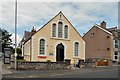
Former Bethania Chapel
The Royal Commission on the Ancient and Historical Monuments of Wales describes Bethania Chapel as a Calvinistic Methodist chapel. "Bethania Methodist Chapel was built in 1886 in the Simple Round-Headed style of the gable entry type. The chapel has pebbledash walls, a slate roof, a chapel house, vestry and Sunday school." http://www.coflein.gov.uk/en/site/7033/details/BETHANIA+CHAPEL+(CALVINISTIC+METHODIST),+NANT-Y-GAMAR+ROAD,+CRAIG-Y-DON/
The Greatorme.org.uk site http://www.greatorme.org.uk/craigydon.html describes it as Welsh Presbyterian chapel. "Eglwys Bresbyteraidd Cymru
Bethania
This little Welsh Presbyterian Chapel on Nant-y-Gamar Road marks the boundary of Craig-y-Don and the end of Mostyn Avenue. It is the point where the electric tramway to Colwyn Bay crossed the road and ran from 1907 to 1956 on a narrow private track through the Bodafon fields."
It is now in the process of being converted into residential accommodation. http://www.matthewjonesarchitects.com/projects/bethania-chapel-conversion-llandudno
I'm informed by Eric Jones that " Welsh Calvinistic Methodists and Presbyterian Church in Wales are one and the same animal. The church officially adopted the name Presbyterian Church in Wales in 1928 but still retained the name Welsh Calvinistic Methodism with equal standing. In the Welsh speaking areas of Gwynedd the term Presbyterian never caught on. Methodistiaid Calfinaidd is still the term used in everyday speech. No one would call himself/herself a "Presbyteriad"."
Image: © Gerald England
Taken: 7 Jul 2014
0.08 miles
7
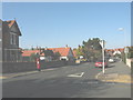
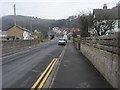
The junction of Carmen Sylva Road and Roumania Drive
Image: © Eric Jones
Taken: 20 Oct 2007
0.09 miles
8

Benchmark on Bethania Chapel, Llandudno
This benchmark can be found at the SE angle of Bethania Chapel in Llandudno. For more details see: http://www.bench-marks.org.uk/bm25519
Image: © Meirion
Taken: 2 Oct 2012
0.09 miles
9
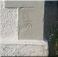
Ordnance Survey Cut Mark
This OS cut mark can be found on the SE angle of the chapel, Nant Y Gamar Road. It marks a point 5.976m above mean sea level.
Image: © Adrian Dust
Taken: 14 Sep 2019
0.09 miles