IMAGES TAKEN NEAR TO
Pentraeth, COLWYN BAY, LL29 9YN
Introduction
This page details the photographs taken nearby to Pentraeth, LL29 9YN by members of the Geograph project.
The Geograph project started in 2005 with the aim of publishing, organising and preserving representative images for every square kilometre of Great Britain, Ireland and the Isle of Man.

There are currently over 7.5m images from over14,400 individuals and you can help contribute to the project by visiting https://www.geograph.org.uk
Image Map
Images are licensed for reuse under creativecommons.org/licenses/by-sa/2.0
Notes
- Clicking on the map will re-center to the selected point.
- The higher the marker number, the further away the image location is from the centre of the postcode.
Image Listing (7 Images Found)
Images are licensed for reuse under creativecommons.org/licenses/by-sa/2.0
Image
Details
Distance
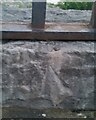
2
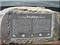
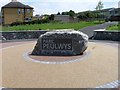
Inscription on the Parc Peulwys stone
Image: © Alex McGregor
Taken: 23 Jul 2014
0.10 miles
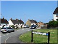
4
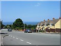
Llysfaen road, Old Colwyn
This use to be on the main bus route to Llysfaen village but is now by-passed due due to parking and width restriction.
Image: © Mike Gentry
Taken: 19 Jan 2011
0.13 miles
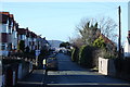
6
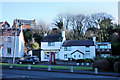
The Post Office, Abergele Road, Penmaenhead, Old Colwyn
Image: © Mike Gentry
Taken: 19 Jan 2011
0.22 miles
7
Ordnance Survey Rivet
This OS rivet can be found on the wall NW side of Abergele Road. It marks a point 73.310m above mean sea level.
Image: © Adrian Dust
Taken: 18 Jun 2021
0.25 miles