IMAGES TAKEN NEAR TO
Abergele Road, COLWYN BAY, LL29 9LD
Introduction
This page details the photographs taken nearby to Abergele Road, LL29 9LD by members of the Geograph project.
The Geograph project started in 2005 with the aim of publishing, organising and preserving representative images for every square kilometre of Great Britain, Ireland and the Isle of Man.

There are currently over 7.5m images from over14,400 individuals and you can help contribute to the project by visiting https://www.geograph.org.uk
Image Map (Loading...)


Getting Data...Please wait
Leaflet Map data © OpenStreetMap
Images are licensed for reuse under creativecommons.org/licenses/by-sa/2.0
Notes
- Clicking on the map will re-center to the selected point.
- The higher the marker number, the further away the image location is from the centre of the postcode.
Image Listing (68 Images Found)
Images are licensed for reuse under creativecommons.org/licenses/by-sa/2.0
Image
Details
Distance
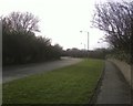
1
Old Milestone by the A547, Old Colwyn
Old milestone on the A547 near to Old Colwyn, Conwy. Parish of Old Conwy (Conwy County Borough District), erected in the 19th Century.
Inscription reads:-
TO / ABERGELE / 4 MILES / TO / CONWAY / 7 MILES / 6 FUR
Milestone Society National ID: DEN_AGCY04
Image: © Debbie Williams
Taken: 14 May 2024
0.04 miles
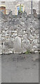
2
Milestone - Abergele 4
The Ordnance Survey cut mark on the stone marks a point 90.271m above mean sea level.
Image: © Adrian Dust
Taken: 18 Jun 2021
0.04 miles
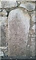
3
Abergele 4
Old milestone on the A547 near to Old Colwyn, Conwy. For overall view see https://www.geograph.org.uk/photo/6726194
Inscription reads:- : TO / ABERGELE / 4 MILES / TO / CONWAY / 7 MILES / 6 FUR :
Milestone Society National ID: DEN_AGCY04
Image: © Keith Evans
Taken: 1 Sep 2019
0.04 miles
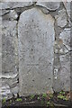
4
Old Milestone
Old mile stone on the A547 near to Old Colwyn, Conwy. For close up view see https://www.geograph.org.uk/photo/6726189
Image: © Keith Evans
Taken: 1 Sep 2019
0.05 miles
5

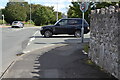
Bryn Colwyn off Abergele Road, Old Colwyn, Colwyn Bay.
Image: © colwynboy
Taken: 9 Apr 2010
0.07 miles
9
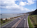
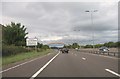
A55 Expressway
The 'Col-Con' section of the A55 dual carriageway presented huge engineering challenges as it was routed along the fringe of the steep, urbanised coast already occupied by quarries and the railway to Holyhead. This photo is from the 'Rainbow Bridge'.
Image: © Jonathan Wilkins
Taken: 23 Apr 2008
0.15 miles