IMAGES TAKEN NEAR TO
Berth Y Glyd Road, COLWYN BAY, LL29 9HT
Introduction
This page details the photographs taken nearby to Berth Y Glyd Road, LL29 9HT by members of the Geograph project.
The Geograph project started in 2005 with the aim of publishing, organising and preserving representative images for every square kilometre of Great Britain, Ireland and the Isle of Man.

There are currently over 7.5m images from over14,400 individuals and you can help contribute to the project by visiting https://www.geograph.org.uk
Image Map
Images are licensed for reuse under creativecommons.org/licenses/by-sa/2.0
Notes
- Clicking on the map will re-center to the selected point.
- The higher the marker number, the further away the image location is from the centre of the postcode.
Image Listing (8 Images Found)
Images are licensed for reuse under creativecommons.org/licenses/by-sa/2.0
Image
Details
Distance
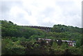
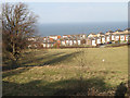
1
View up from the Coastal Path
The A55 Expressway runs parallel to the Coast Path. Beyond is Llanddulas Quarry, and perched on top with a great view to the sea but a rather precarious position, are houses.
Image: © Eirian Evans
Taken: 14 Jan 2012
0.12 miles
3
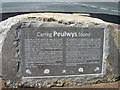
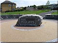
Inscription on the Parc Peulwys stone
Image: © Alex McGregor
Taken: 23 Jul 2014
0.18 miles
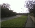
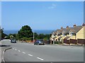
6
Grazing by Peulwys Lane
Sheep on grazing land above the housing estate, seen from Ty Mawr farmyard.
Image: © Jonathan Wilkins
Taken: 23 Jan 2009
0.22 miles
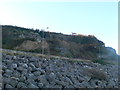
7
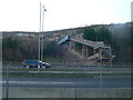
Looking across the A55 at Llanddulas Quarry
Limestone aggregates are quarried here and transported by sea to various locations in the UK and the near-continent for use in the construction and chemical industries.
Image: © Eirian Evans
Taken: 14 Jan 2012
0.22 miles