IMAGES TAKEN NEAR TO
Station Road, COLWYN BAY, LL29 9EF
Introduction
This page details the photographs taken nearby to Station Road, LL29 9EF by members of the Geograph project.
The Geograph project started in 2005 with the aim of publishing, organising and preserving representative images for every square kilometre of Great Britain, Ireland and the Isle of Man.

There are currently over 7.5m images from over14,400 individuals and you can help contribute to the project by visiting https://www.geograph.org.uk
Image Map (Loading...)


Getting Data...Please wait
Leaflet Map data © OpenStreetMap
Images are licensed for reuse under creativecommons.org/licenses/by-sa/2.0
Notes
- Clicking on the map will re-center to the selected point.
- The higher the marker number, the further away the image location is from the centre of the postcode.
Image Listing (98 Images Found)
Images are licensed for reuse under creativecommons.org/licenses/by-sa/2.0
Image
Details
Distance
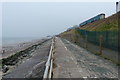
2
Footpath with bench
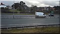
The construction of the A55 Expressway along this stretch required the demolition of a number of houses and one side of a short street to the east of this point, so it is appropriate that land here has been given back to the people, although it is not peaceful and the view is not special.
Image: © Jonathan Wilkins
Taken: 18 Mar 2009
0.06 miles
3
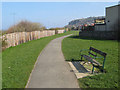
Nautical garden
A very amusing beachscape has been created on the edge of this green space, complete with a tide-line of blue mussel shells and some amorous seahorses on the edge of the 'dunes'. Top marks!
Image: © Jonathan Wilkins
Taken: 18 Mar 2009
0.07 miles
5
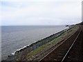
Old Colwyn railway station (site)
Opened in 1884 as "Colwyn" by the London & North Western Railway on the line from Chester to Holyhead, this station became "Old Colwyn" the following year to avoid confusion with the "Colwyn Bay" station. It closed to passengers in 1952 and completely in 1964.
View east from a passing train. The platform here was a wooden construction jutting out from the embankment, and quite prominent from the beach below! The main station buildings were to the right of the track.
Image: © Nigel Thompson
Taken: 2 May 2018
0.08 miles
6
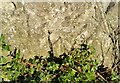
Ordnance Survey Cut Mark
This OS cut mark can be found on the wall SE side of Station Road. It marks a point 18.564m above mean sea level.
Image: © Adrian Dust
Taken: 17 Jun 2021
0.08 miles
7
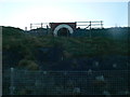
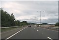
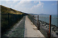
Way to go
The tunnel provides a means of exit from the coast path to Station Road, Old Colwyn. It goes under the railway.
Image: © Eirian Evans
Taken: 14 Jan 2012
0.09 miles
10
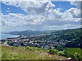
Old Colwyn and Colwyn Bay
View from Bryn Euryn.
Image: © Alan Hughes
Taken: 22 Jun 2024
0.10 miles