IMAGES TAKEN NEAR TO
Llanelian, COLWYN BAY, LL29 8YY
Introduction
This page details the photographs taken nearby to LL29 8YY by members of the Geograph project.
The Geograph project started in 2005 with the aim of publishing, organising and preserving representative images for every square kilometre of Great Britain, Ireland and the Isle of Man.

There are currently over 7.5m images from over14,400 individuals and you can help contribute to the project by visiting https://www.geograph.org.uk
Image Map
Images are licensed for reuse under creativecommons.org/licenses/by-sa/2.0
Notes
- Clicking on the map will re-center to the selected point.
- The higher the marker number, the further away the image location is from the centre of the postcode.
Image Listing (4 Images Found)
Images are licensed for reuse under creativecommons.org/licenses/by-sa/2.0
Image
Details
Distance
1
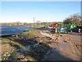
Solar Park site facilities
A new solar power generation array has been constructed recently on farmland near Dolwen. This is a view of the site facilities area for the construction company, which are not permanent. The sudden return of strong sunshine after months of clouds and rain must have been very welcome.
Image: © Jonathan Wilkins
Taken: 20 Jan 2016
0.15 miles
2
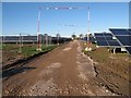
Solar Park
A view along the central roadway showing the extent of the photovoltaic panel installation. The North Wales coast is not an area that would spring immediately to mind for solar power generation, so the fantastic sunshine of the first day we have seen this year of decent illumination must be a boon. I am grateful to the site contractors for access for this image, but I was not allowed any further for a more picturesque composition.
Image: © Jonathan Wilkins
Taken: 20 Jan 2016
0.20 miles